You are here: Home > Network List > TA - USArray Transportable Network (new EarthScope stations) Stations List
> Station SFIN Lafayette, IN, USA > Earthquake Result Viewer
SFIN Lafayette, IN, USA - Earthquake Result Viewer
| Earthquake location: |
Jan Mayen Island Region |
| Earthquake latitude/longitude: |
70.9/-6.7 |
| Earthquake time(UTC): |
2011/01/29 (029) 06:55:26 GMT |
| Earthquake Depth: |
6.0 km |
| Earthquake Magnitude: |
6.1 MB, 6.1 MS, 6.2 MW, 6.2 MW |
| Earthquake Catalog/Contributor: |
WHDF/NEIC |
|
| Network: |
TA USArray Transportable Network (new EarthScope stations) |
| Station: |
SFIN Lafayette, IN, USA |
| Lat/Lon: |
40.38 N/87.10 W |
| Elevation: |
165 m |
|
| Distance: |
49.4 deg |
| Az: |
276.959 deg |
| Baz: |
25.275 deg |
| Ray Param: |
0.068758115 |
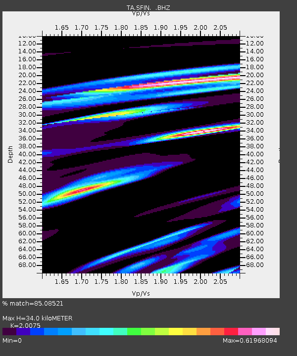
| Estimated Moho Depth: |
34.0 km |
| Estimated Crust Vp/Vs: |
2.01 |
| Assumed Crust Vp: |
6.498 km/s |
| Estimated Crust Vs: |
3.237 km/s |
| Estimated Crust Poisson's Ratio: |
0.33 |
|
| Radial Match: |
85.08521 % |
| Radial Bump: |
400 |
| Transverse Match: |
57.235176 % |
| Transverse Bump: |
319 |
| SOD ConfigId: |
350818 |
| Insert Time: |
2011-07-20 07:55:27.673 +0000 |
| GWidth: |
2.5 |
| Max Bumps: |
400 |
| Tol: |
0.001 |
|
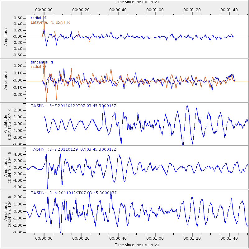
Signal To Noise
| Channel | StoN | STA | LTA |
| TA:SFIN: :BHZ:20110129T07:03:45.300013Z | 5.2754006 | 2.3494804E-6 | 4.453653E-7 |
| TA:SFIN: :BHN:20110129T07:03:45.300013Z | 1.6024102 | 1.0284123E-6 | 6.417909E-7 |
| TA:SFIN: :BHE:20110129T07:03:45.300013Z | 2.1259725 | 1.2056702E-6 | 5.671147E-7 |
| Arrivals |
| Ps | 5.6 SECOND |
| PpPs | 15 SECOND |
| PsPs/PpSs | 20 SECOND |


