You are here: Home > Network List > TA - USArray Transportable Network (new EarthScope stations) Stations List
> Station 230A Sterling City, TX, USA > Earthquake Result Viewer
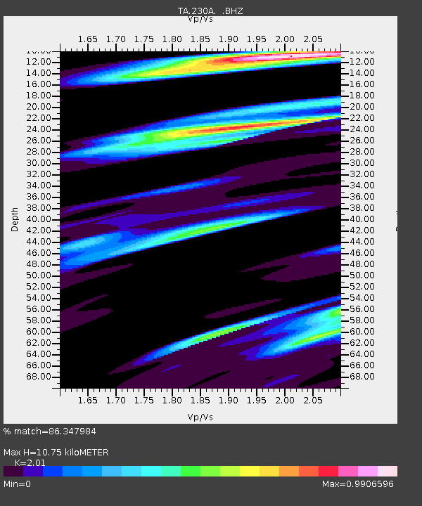
230A Sterling City, TX, USA - Earthquake Result Viewer
| Earthquake location: |
Jan Mayen Island Region |
| Earthquake latitude/longitude: |
70.9/-6.7 |
| Earthquake time(UTC): |
2011/01/29 (029) 06:55:26 GMT |
| Earthquake Depth: |
6.0 km |
| Earthquake Magnitude: |
6.1 MB, 6.1 MS, 6.2 MW, 6.2 MW |
| Earthquake Catalog/Contributor: |
WHDF/NEIC |
|
| Network: |
TA USArray Transportable Network (new EarthScope stations) |
| Station: |
230A Sterling City, TX, USA |
| Lat/Lon: |
31.89 N/101.11 W |
| Elevation: |
742 m |
|
| Distance: |
61.6 deg |
| Az: |
285.477 deg |
| Baz: |
21.855 deg |
| Ray Param: |
0.060749326 |
| Estimated Moho Depth: |
10.75 km |
| Estimated Crust Vp/Vs: |
2.01 |
| Assumed Crust Vp: |
6.38 km/s |
| Estimated Crust Vs: |
3.174 km/s |
| Estimated Crust Poisson's Ratio: |
0.34 |
|
| Radial Match: |
86.347984 % |
| Radial Bump: |
400 |
| Transverse Match: |
58.62733 % |
| Transverse Bump: |
400 |
| SOD ConfigId: |
350818 |
| Insert Time: |
2011-07-20 07:58:15.596 +0000 |
| GWidth: |
2.5 |
| Max Bumps: |
400 |
| Tol: |
0.001 |
|

Signal To Noise
| Channel | StoN | STA | LTA |
| TA:230A: :BHZ:20110129T07:05:13.52502Z | 2.480455 | 1.7969188E-6 | 7.244312E-7 |
| TA:230A: :BHN:20110129T07:05:13.52502Z | 1.3768536 | 1.1483436E-6 | 8.340347E-7 |
| TA:230A: :BHE:20110129T07:05:13.52502Z | 2.8450344 | 6.829309E-7 | 2.400431E-7 |
| Arrivals |
| Ps | 1.8 SECOND |
| PpPs | 4.9 SECOND |
| PsPs/PpSs | 6.6 SECOND |


