You are here: Home > Network List > XG92 - Rocky Mountain Front Stations List
> Station LMN Limon, CO > Earthquake Result Viewer
LMN Limon, CO - Earthquake Result Viewer
| Earthquake location: |
Hokkaido, Japan Region |
| Earthquake latitude/longitude: |
41.4/142.1 |
| Earthquake time(UTC): |
1992/07/12 (194) 11:08:56 GMT |
| Earthquake Depth: |
70 km |
| Earthquake Magnitude: |
5.9 MB |
| Earthquake Catalog/Contributor: |
WHDF/NEIC |
|
| Network: |
XG Rocky Mountain Front |
| Station: |
LMN Limon, CO |
| Lat/Lon: |
39.42 N/103.62 W |
| Elevation: |
1665 m |
|
| Distance: |
79.8 deg |
| Az: |
45.823 deg |
| Baz: |
315.888 deg |
| Ray Param: |
0.048570447 |
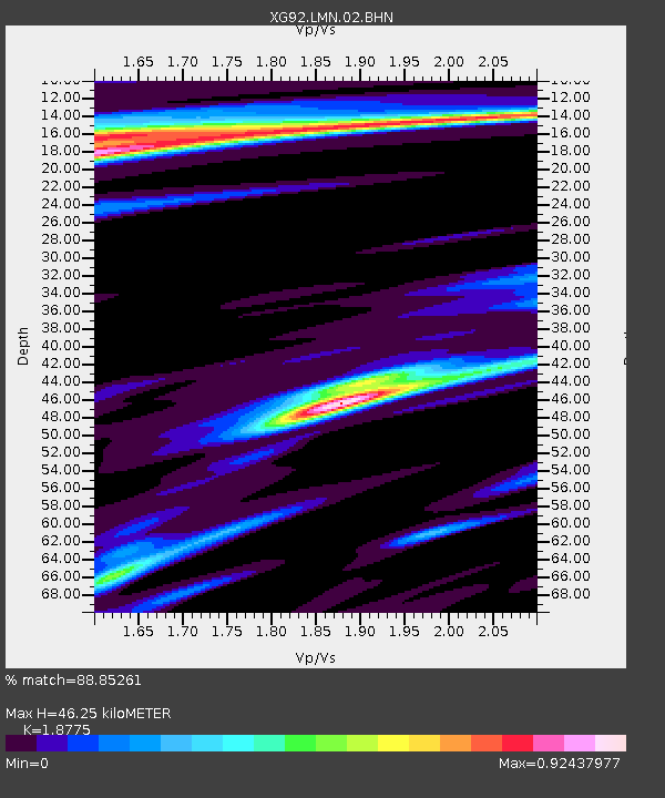
| Estimated Moho Depth: |
46.25 km |
| Estimated Crust Vp/Vs: |
1.88 |
| Assumed Crust Vp: |
6.242 km/s |
| Estimated Crust Vs: |
3.325 km/s |
| Estimated Crust Poisson's Ratio: |
0.30 |
|
| Radial Match: |
88.85261 % |
| Radial Bump: |
341 |
| Transverse Match: |
74.63796 % |
| Transverse Bump: |
400 |
| SOD ConfigId: |
3286 |
| Insert Time: |
2010-02-25 20:09:55.938 +0000 |
| GWidth: |
2.5 |
| Max Bumps: |
400 |
| Tol: |
0.001 |
|

Signal To Noise
| Channel | StoN | STA | LTA |
| XG:LMN:02:BHN:19920712T11:20:25.630005Z | 1.091006 | 1.3936336E-4 | 1.2773839E-4 |
| XG:LMN:02:BHE:19920712T11:20:25.630005Z | 0.53049785 | 1.02049795E-4 | 1.9236609E-4 |
| XG:LMN:02:BHZ:19920712T11:20:25.630005Z | 7.99391 | 7.2384643E-4 | 9.0549736E-5 |
| Arrivals |
| Ps | 6.7 SECOND |
| PpPs | 21 SECOND |
| PsPs/PpSs | 27 SECOND |


