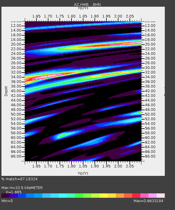
HWB AZ.HWB - Earthquake Result Viewer

Earthquake location: Near West Coast Of Honshu, Japan
Earthquake latitude/longitude: 37.2/138.8
Earthquake time(UTC): 2004/10/23 (297) 08:56:00 GMT
Earthquake Depth: 16 km
Earthquake Magnitude: 6.4 MB, 6.3 MS, 6.6 MW, 6.4 MW
Earthquake Catalog/Contributor: WHDF/NEIC
Network: AZ ANZA Regional Network
Station: HWB AZ.HWB
Lat/Lon: 33.03 N/116.96 W
Elevation: 478 m
Distance: 80.7 deg
Az: 55.592 deg
Baz: 308.38 deg
Ray Param: 0.048086755
Estimated Moho Depth: 33.5 km
Estimated Crust Vp/Vs: 1.70
Assumed Crust Vp: 6.264 km/s
Estimated Crust Vs: 3.695 km/s
Estimated Crust Poisson's Ratio: 0.23
Radial Match: 87.18324 %
Radial Bump: 400
Transverse Match: 66.436554 %
Transverse Bump: 400
SOD ConfigId: 2459
Insert Time: 2010-02-26 19:24:42.351 +0000
GWidth: 2.5
Max Bumps: 400
Tol: 0.001

Signal To Noise

ChannelStoNSTALTA
AZ:HWB: :BHN:20041023T09:07:41.664016Z1.17959882.2223789E-71.8840124E-7
AZ:HWB: :BHE:20041023T09:07:41.664016Z0.544088661.2769297E-72.3469147E-7
AZ:HWB: :BHZ:20041023T09:07:41.664016Z7.7100065.8724146E-77.6166145E-8
Arrivals
Ps3.8 SECOND
PpPs14 SECOND
PsPs/PpSs18 SECOND