You are here: Home > Network List > TA - USArray Transportable Network (new EarthScope stations) Stations List
> Station A26A Wade Farm, Kenmare, ND, USA > Earthquake Result Viewer
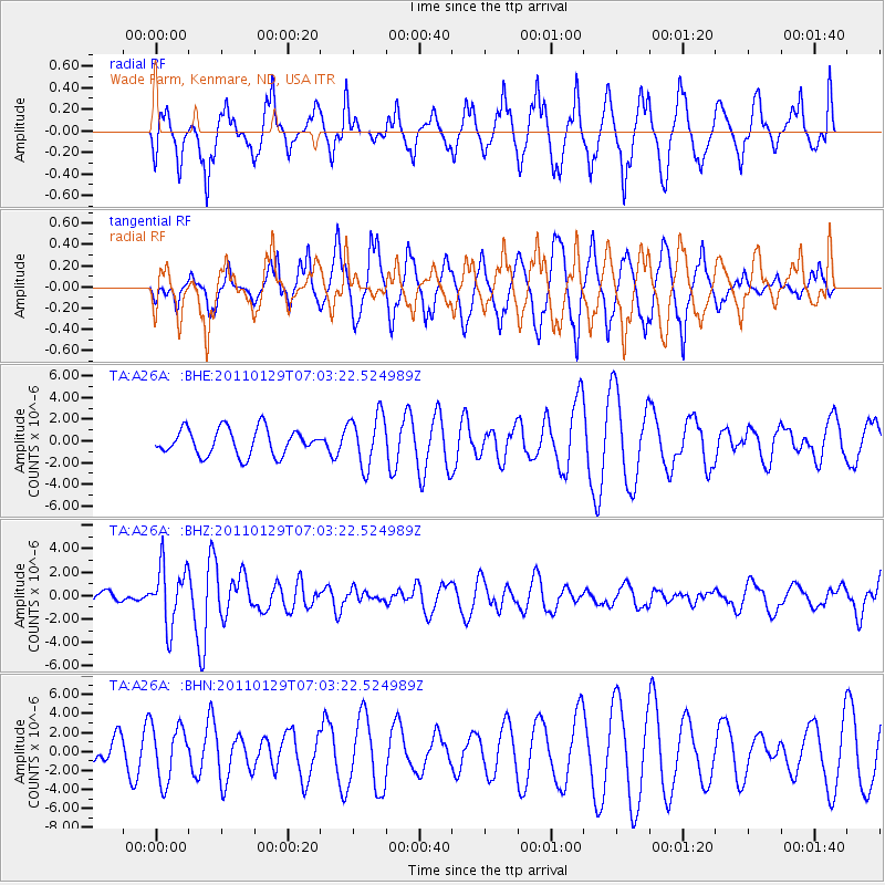
A26A Wade Farm, Kenmare, ND, USA - Earthquake Result Viewer
*The percent match for this event was below the threshold and hence no stack was calculated.
| Earthquake location: |
Jan Mayen Island Region |
| Earthquake latitude/longitude: |
70.9/-6.7 |
| Earthquake time(UTC): |
2011/01/29 (029) 06:55:26 GMT |
| Earthquake Depth: |
6.0 km |
| Earthquake Magnitude: |
6.1 MB, 6.1 MS, 6.2 MW, 6.2 MW |
| Earthquake Catalog/Contributor: |
WHDF/NEIC |
|
| Network: |
TA USArray Transportable Network (new EarthScope stations) |
| Station: |
A26A Wade Farm, Kenmare, ND, USA |
| Lat/Lon: |
48.90 N/102.04 W |
| Elevation: |
570 m |
|
| Distance: |
46.4 deg |
| Az: |
294.908 deg |
| Baz: |
26.847 deg |
| Ray Param: |
$rayparam |
*The percent match for this event was below the threshold and hence was not used in the summary stack. |
|
| Radial Match: |
62.246784 % |
| Radial Bump: |
329 |
| Transverse Match: |
67.7353 % |
| Transverse Bump: |
312 |
| SOD ConfigId: |
350818 |
| Insert Time: |
2011-07-20 08:22:43.049 +0000 |
| GWidth: |
2.5 |
| Max Bumps: |
400 |
| Tol: |
0.001 |
|
Signal To Noise
| Channel | StoN | STA | LTA |
| TA:A26A: :BHZ:20110129T07:03:22.524989Z | 5.5208445 | 2.5320917E-6 | 4.586421E-7 |
| TA:A26A: :BHN:20110129T07:03:22.524989Z | 0.6875288 | 2.919319E-6 | 4.2461043E-6 |
| TA:A26A: :BHE:20110129T07:03:22.524989Z | 1.9564962 | 2.376418E-6 | 1.2146295E-6 |
| Arrivals |
| Ps | |
| PpPs | |
| PsPs/PpSs | |


