You are here: Home > Network List > TA - USArray Transportable Network (new EarthScope stations) Stations List
> Station K30A Basset, NE, USA > Earthquake Result Viewer
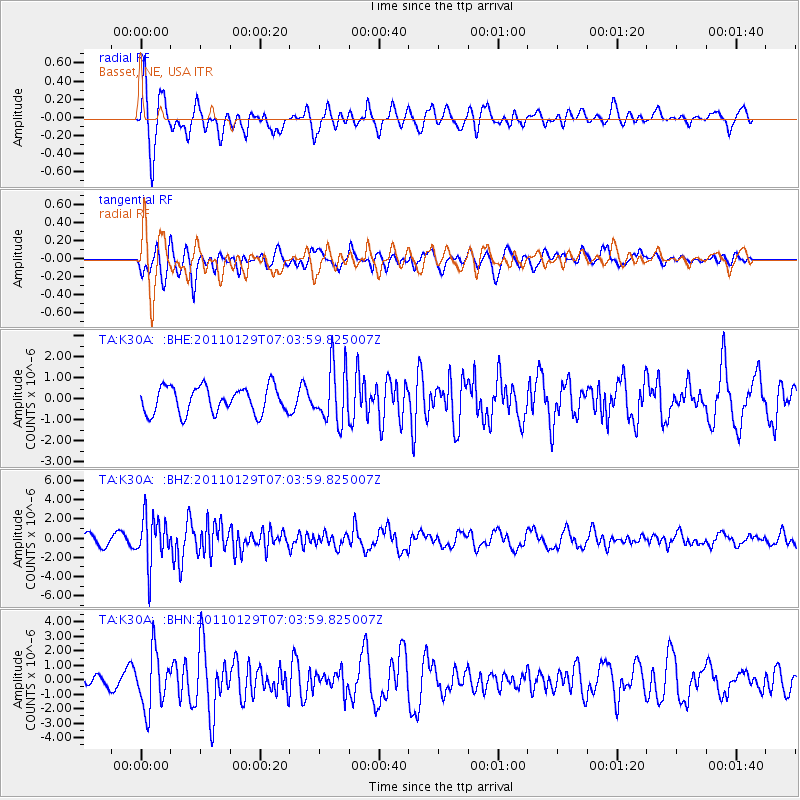
K30A Basset, NE, USA - Earthquake Result Viewer

| Earthquake location: |
Jan Mayen Island Region |
| Earthquake latitude/longitude: |
70.9/-6.7 |
| Earthquake time(UTC): |
2011/01/29 (029) 06:55:26 GMT |
| Earthquake Depth: |
6.0 km |
| Earthquake Magnitude: |
6.1 MB, 6.1 MS, 6.2 MW, 6.2 MW |
| Earthquake Catalog/Contributor: |
WHDF/NEIC |
|
| Network: |
TA USArray Transportable Network (new EarthScope stations) |
| Station: |
K30A Basset, NE, USA |
| Lat/Lon: |
42.67 N/99.61 W |
| Elevation: |
712 m |
|
| Distance: |
51.3 deg |
| Az: |
289.275 deg |
| Baz: |
24.871 deg |
| Ray Param: |
0.06752021 |
| Estimated Moho Depth: |
21.25 km |
| Estimated Crust Vp/Vs: |
2.10 |
| Assumed Crust Vp: |
6.53 km/s |
| Estimated Crust Vs: |
3.113 km/s |
| Estimated Crust Poisson's Ratio: |
0.35 |
|
| Radial Match: |
84.13977 % |
| Radial Bump: |
400 |
| Transverse Match: |
62.560913 % |
| Transverse Bump: |
400 |
| SOD ConfigId: |
350818 |
| Insert Time: |
2011-07-20 08:35:00.562 +0000 |
| GWidth: |
2.5 |
| Max Bumps: |
400 |
| Tol: |
0.001 |
|
Signal To Noise
| Channel | StoN | STA | LTA |
| TA:K30A: :BHZ:20110129T07:03:59.825007Z | 6.075287 | 2.469274E-6 | 4.0644565E-7 |
| TA:K30A: :BHN:20110129T07:03:59.825007Z | 3.268101 | 1.9323406E-6 | 5.912732E-7 |
| TA:K30A: :BHE:20110129T07:03:59.825007Z | 2.1242588 | 1.3266143E-6 | 6.2450687E-7 |
| Arrivals |
| Ps | 3.8 SECOND |
| PpPs | 9.6 SECOND |
| PsPs/PpSs | 13 SECOND |


