You are here: Home > Network List > AZ - ANZA Regional Network Stations List
> Station HWB AZ.HWB > Earthquake Result Viewer
HWB AZ.HWB - Earthquake Result Viewer
| Earthquake location: |
Rat Islands, Aleutian Islands |
| Earthquake latitude/longitude: |
51.2/179.4 |
| Earthquake time(UTC): |
2005/06/14 (165) 17:10:16 GMT |
| Earthquake Depth: |
51 km |
| Earthquake Magnitude: |
6.0 MB, 6.8 MW, 6.6 MW |
| Earthquake Catalog/Contributor: |
WHDF/NEIC |
|
| Network: |
AZ ANZA Regional Network |
| Station: |
HWB AZ.HWB |
| Lat/Lon: |
33.03 N/116.96 W |
| Elevation: |
478 m |
|
| Distance: |
49.0 deg |
| Az: |
86.129 deg |
| Baz: |
311.695 deg |
| Ray Param: |
0.0688657 |
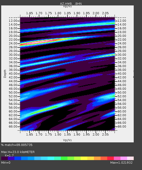
| Estimated Moho Depth: |
23.0 km |
| Estimated Crust Vp/Vs: |
1.70 |
| Assumed Crust Vp: |
6.264 km/s |
| Estimated Crust Vs: |
3.684 km/s |
| Estimated Crust Poisson's Ratio: |
0.24 |
|
| Radial Match: |
89.885735 % |
| Radial Bump: |
400 |
| Transverse Match: |
60.453705 % |
| Transverse Bump: |
400 |
| SOD ConfigId: |
32974 |
| Insert Time: |
2010-02-26 19:24:51.964 +0000 |
| GWidth: |
2.5 |
| Max Bumps: |
400 |
| Tol: |
0.001 |
|

Signal To Noise
| Channel | StoN | STA | LTA |
| AZ:HWB: :BHN:20050614T17:18:27.46901Z | 2.3516304 | 3.7906744E-7 | 1.6119346E-7 |
| AZ:HWB: :BHE:20050614T17:18:27.46901Z | 1.6903766 | 1.7944076E-7 | 1.061543E-7 |
| AZ:HWB: :BHZ:20050614T17:18:27.46901Z | 10.525207 | 5.1625784E-7 | 4.9049664E-8 |
| Arrivals |
| Ps | 2.7 SECOND |
| PpPs | 9.4 SECOND |
| PsPs/PpSs | 12 SECOND |


