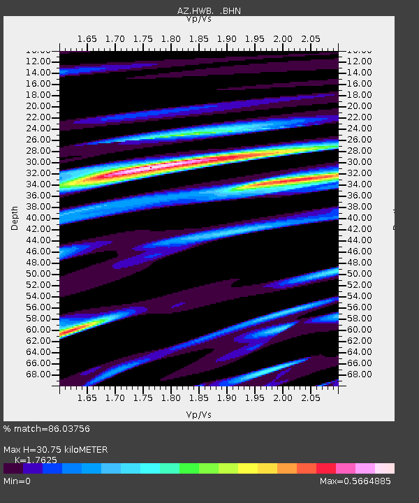
HWB AZ.HWB - Earthquake Result Viewer

Earthquake location: South Of Kermadec Islands
Earthquake latitude/longitude: -32.6/-179.4
Earthquake time(UTC): 2005/05/16 (136) 03:54:14 GMT
Earthquake Depth: 34 km
Earthquake Magnitude: 6.2 MB, 6.4 MS, 6.6 MW, 6.6 MW
Earthquake Catalog/Contributor: WHDF/NEIC
Network: AZ ANZA Regional Network
Station: HWB AZ.HWB
Lat/Lon: 33.03 N/116.96 W
Elevation: 478 m
Distance: 87.8 deg
Az: 48.157 deg
Baz: 228.471 deg
Ray Param: 0.04299375
Estimated Moho Depth: 30.75 km
Estimated Crust Vp/Vs: 1.76
Assumed Crust Vp: 6.264 km/s
Estimated Crust Vs: 3.554 km/s
Estimated Crust Poisson's Ratio: 0.26
Radial Match: 86.03756 %
Radial Bump: 400
Transverse Match: 69.148125 %
Transverse Bump: 400
SOD ConfigId: 32974
Insert Time: 2010-02-26 19:24:55.204 +0000
GWidth: 2.5
Max Bumps: 400
Tol: 0.001

Signal To Noise

ChannelStoNSTALTA
AZ:HWB: :BHN:20050516T04:06:29.195012Z3.14329391.2618864E-74.0145352E-8
AZ:HWB: :BHE:20050516T04:06:29.195012Z1.74278599.403913E-85.395908E-8
AZ:HWB: :BHZ:20050516T04:06:29.195012Z8.3137434.7763217E-75.7450922E-8
Arrivals
Ps3.8 SECOND
PpPs13 SECOND
PsPs/PpSs17 SECOND