You are here: Home > Network List > TA - USArray Transportable Network (new EarthScope stations) Stations List
> Station 436A Wall Ranch, Gause, TX, USA > Earthquake Result Viewer
436A Wall Ranch, Gause, TX, USA - Earthquake Result Viewer
*The percent match for this event was below the threshold and hence no stack was calculated.
| Earthquake location: |
Jan Mayen Island Region |
| Earthquake latitude/longitude: |
70.9/-6.7 |
| Earthquake time(UTC): |
2011/01/29 (029) 06:55:26 GMT |
| Earthquake Depth: |
6.0 km |
| Earthquake Magnitude: |
6.1 MB, 6.1 MS, 6.2 MW, 6.2 MW |
| Earthquake Catalog/Contributor: |
WHDF/NEIC |
|
| Network: |
TA USArray Transportable Network (new EarthScope stations) |
| Station: |
436A Wall Ranch, Gause, TX, USA |
| Lat/Lon: |
30.77 N/96.80 W |
| Elevation: |
109 m |
|
| Distance: |
61.3 deg |
| Az: |
281.104 deg |
| Baz: |
22.0 deg |
| Ray Param: |
$rayparam |
*The percent match for this event was below the threshold and hence was not used in the summary stack. |
|
| Radial Match: |
55.92181 % |
| Radial Bump: |
291 |
| Transverse Match: |
70.50477 % |
| Transverse Bump: |
400 |
| SOD ConfigId: |
350818 |
| Insert Time: |
2011-07-20 08:55:26.150 +0000 |
| GWidth: |
2.5 |
| Max Bumps: |
400 |
| Tol: |
0.001 |
|
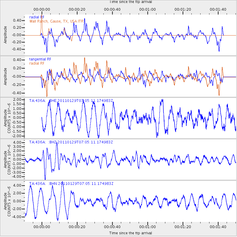
Signal To Noise
| Channel | StoN | STA | LTA |
| TA:436A: :BHZ:20110129T07:05:11.174983Z | 2.8588555 | 1.8985286E-6 | 6.640869E-7 |
| TA:436A: :BHN:20110129T07:05:11.174983Z | 1.4423892 | 2.1972132E-6 | 1.5233151E-6 |
| TA:436A: :BHE:20110129T07:05:11.174983Z | 1.313138 | 1.3195092E-6 | 1.0048519E-6 |
| Arrivals |
| Ps | |
| PpPs | |
| PsPs/PpSs | |


