You are here: Home > Network List > TA - USArray Transportable Network (new EarthScope stations) Stations List
> Station 137A Heron Place, Grans Saline, TX, USA > Earthquake Result Viewer
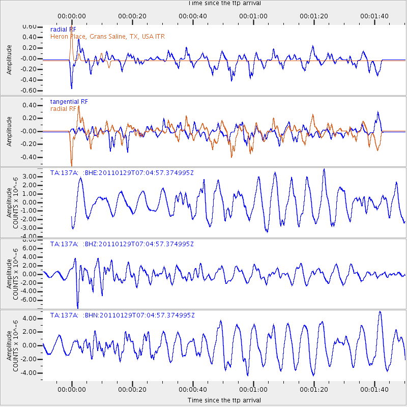
137A Heron Place, Grans Saline, TX, USA - Earthquake Result Viewer
*The percent match for this event was below the threshold and hence no stack was calculated.
| Earthquake location: |
Jan Mayen Island Region |
| Earthquake latitude/longitude: |
70.9/-6.7 |
| Earthquake time(UTC): |
2011/01/29 (029) 06:55:26 GMT |
| Earthquake Depth: |
6.0 km |
| Earthquake Magnitude: |
6.1 MB, 6.1 MS, 6.2 MW, 6.2 MW |
| Earthquake Catalog/Contributor: |
WHDF/NEIC |
|
| Network: |
TA USArray Transportable Network (new EarthScope stations) |
| Station: |
137A Heron Place, Grans Saline, TX, USA |
| Lat/Lon: |
32.60 N/95.76 W |
| Elevation: |
141 m |
|
| Distance: |
59.3 deg |
| Az: |
280.953 deg |
| Baz: |
22.469 deg |
| Ray Param: |
$rayparam |
*The percent match for this event was below the threshold and hence was not used in the summary stack. |
|
| Radial Match: |
66.68208 % |
| Radial Bump: |
400 |
| Transverse Match: |
63.14135 % |
| Transverse Bump: |
400 |
| SOD ConfigId: |
350818 |
| Insert Time: |
2011-07-20 08:59:20.502 +0000 |
| GWidth: |
2.5 |
| Max Bumps: |
400 |
| Tol: |
0.001 |
|
Signal To Noise
| Channel | StoN | STA | LTA |
| TA:137A: :BHZ:20110129T07:04:57.374995Z | 4.255057 | 2.7974743E-6 | 6.5744695E-7 |
| TA:137A: :BHN:20110129T07:04:57.374995Z | 0.9274956 | 7.034332E-7 | 7.584221E-7 |
| TA:137A: :BHE:20110129T07:04:57.374995Z | 0.9307604 | 1.1295891E-6 | 1.2136197E-6 |
| Arrivals |
| Ps | |
| PpPs | |
| PsPs/PpSs | |


