You are here: Home > Network List > AZ - ANZA Regional Network Stations List
> Station HWB AZ.HWB > Earthquake Result Viewer
HWB AZ.HWB - Earthquake Result Viewer

| Earthquake location: |
New Ireland Region, P.N.G. |
| Earthquake latitude/longitude: |
-4.5/153.5 |
| Earthquake time(UTC): |
2005/09/09 (252) 07:26:43 GMT |
| Earthquake Depth: |
90 km |
| Earthquake Magnitude: |
6.3 MB, 7.7 MW, 7.5 MW |
| Earthquake Catalog/Contributor: |
WHDF/NEIC |
|
| Network: |
AZ ANZA Regional Network |
| Station: |
HWB AZ.HWB |
| Lat/Lon: |
33.03 N/116.96 W |
| Elevation: |
478 m |
|
| Distance: |
92.1 deg |
| Az: |
57.205 deg |
| Baz: |
265.976 deg |
| Ray Param: |
0.04147608 |
| Estimated Moho Depth: |
27.75 km |
| Estimated Crust Vp/Vs: |
2.09 |
| Assumed Crust Vp: |
6.264 km/s |
| Estimated Crust Vs: |
2.993 km/s |
| Estimated Crust Poisson's Ratio: |
0.35 |
|
| Radial Match: |
92.58556 % |
| Radial Bump: |
375 |
| Transverse Match: |
80.96765 % |
| Transverse Bump: |
400 |
| SOD ConfigId: |
2475 |
| Insert Time: |
2010-02-26 19:25:07.384 +0000 |
| GWidth: |
2.5 |
| Max Bumps: |
400 |
| Tol: |
0.001 |
|
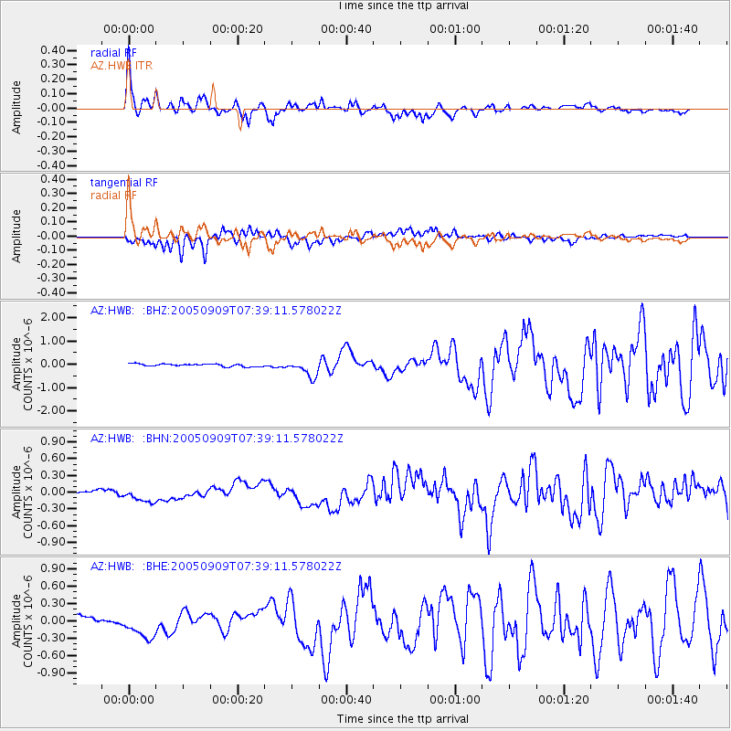
Signal To Noise
| Channel | StoN | STA | LTA |
| AZ:HWB: :BHN:20050909T07:39:11.578022Z | 1.3550744 | 1.2389431E-7 | 9.14299E-8 |
| AZ:HWB: :BHE:20050909T07:39:11.578022Z | 2.1233416 | 2.4178297E-7 | 1.13869085E-7 |
| AZ:HWB: :BHZ:20050909T07:39:11.578022Z | 6.5929365 | 3.60644E-7 | 5.4701577E-8 |
| Arrivals |
| Ps | 4.9 SECOND |
| PpPs | 13 SECOND |
| PsPs/PpSs | 18 SECOND |


