You are here: Home > Network List > TA - USArray Transportable Network (new EarthScope stations) Stations List
> Station K33A Hardington, NE, USA > Earthquake Result Viewer
K33A Hardington, NE, USA - Earthquake Result Viewer
| Earthquake location: |
Jan Mayen Island Region |
| Earthquake latitude/longitude: |
70.9/-6.7 |
| Earthquake time(UTC): |
2011/01/29 (029) 06:55:26 GMT |
| Earthquake Depth: |
6.0 km |
| Earthquake Magnitude: |
6.1 MB, 6.1 MS, 6.2 MW, 6.2 MW |
| Earthquake Catalog/Contributor: |
WHDF/NEIC |
|
| Network: |
TA USArray Transportable Network (new EarthScope stations) |
| Station: |
K33A Hardington, NE, USA |
| Lat/Lon: |
42.61 N/97.00 W |
| Elevation: |
507 m |
|
| Distance: |
50.5 deg |
| Az: |
286.988 deg |
| Baz: |
25.191 deg |
| Ray Param: |
0.068005316 |
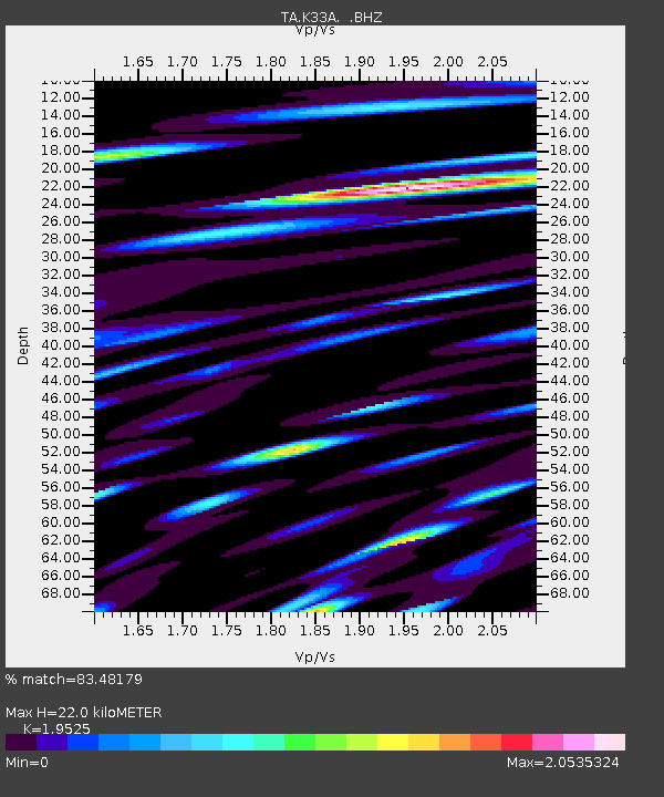
| Estimated Moho Depth: |
22.0 km |
| Estimated Crust Vp/Vs: |
1.95 |
| Assumed Crust Vp: |
6.498 km/s |
| Estimated Crust Vs: |
3.328 km/s |
| Estimated Crust Poisson's Ratio: |
0.32 |
|
| Radial Match: |
83.48179 % |
| Radial Bump: |
400 |
| Transverse Match: |
65.784294 % |
| Transverse Bump: |
400 |
| SOD ConfigId: |
350818 |
| Insert Time: |
2011-07-20 09:20:04.629 +0000 |
| GWidth: |
2.5 |
| Max Bumps: |
400 |
| Tol: |
0.001 |
|
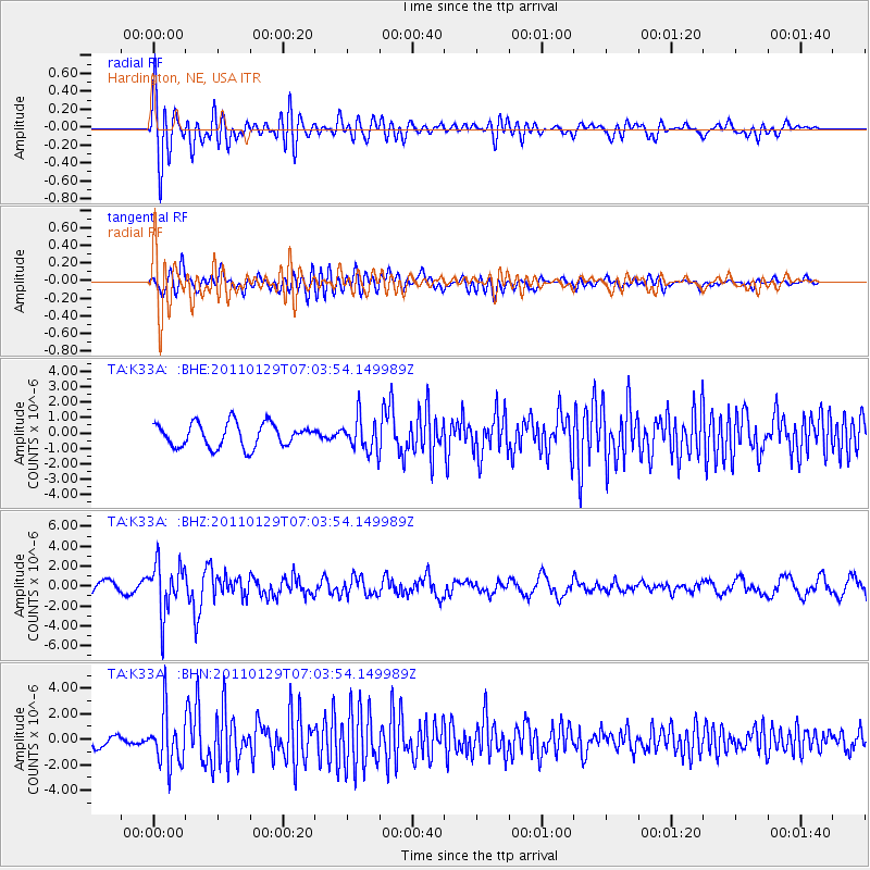
Signal To Noise
| Channel | StoN | STA | LTA |
| TA:K33A: :BHZ:20110129T07:03:54.149989Z | 3.8253784 | 2.5474499E-6 | 6.6593407E-7 |
| TA:K33A: :BHN:20110129T07:03:54.149989Z | 5.020079 | 2.0315579E-6 | 4.0468643E-7 |
| TA:K33A: :BHE:20110129T07:03:54.149989Z | 1.4268342 | 1.0936594E-6 | 7.664937E-7 |
| Arrivals |
| Ps | 3.4 SECOND |
| PpPs | 9.5 SECOND |
| PsPs/PpSs | 13 SECOND |


