You are here: Home > Network List > TA - USArray Transportable Network (new EarthScope stations) Stations List
> Station D36A Goodland, MN, USA > Earthquake Result Viewer
D36A Goodland, MN, USA - Earthquake Result Viewer
| Earthquake location: |
Jan Mayen Island Region |
| Earthquake latitude/longitude: |
70.9/-6.7 |
| Earthquake time(UTC): |
2011/01/29 (029) 06:55:26 GMT |
| Earthquake Depth: |
6.0 km |
| Earthquake Magnitude: |
6.1 MB, 6.1 MS, 6.2 MW, 6.2 MW |
| Earthquake Catalog/Contributor: |
WHDF/NEIC |
|
| Network: |
TA USArray Transportable Network (new EarthScope stations) |
| Station: |
D36A Goodland, MN, USA |
| Lat/Lon: |
47.18 N/93.16 W |
| Elevation: |
434 m |
|
| Distance: |
45.2 deg |
| Az: |
286.427 deg |
| Baz: |
27.516 deg |
| Ray Param: |
0.071428895 |
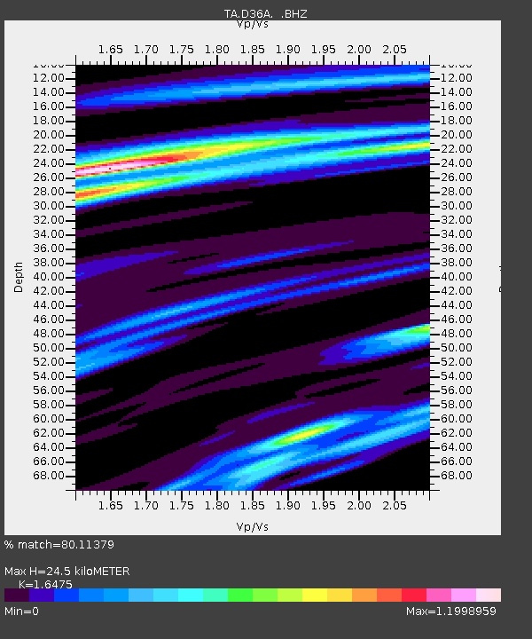
| Estimated Moho Depth: |
24.5 km |
| Estimated Crust Vp/Vs: |
1.65 |
| Assumed Crust Vp: |
6.571 km/s |
| Estimated Crust Vs: |
3.988 km/s |
| Estimated Crust Poisson's Ratio: |
0.21 |
|
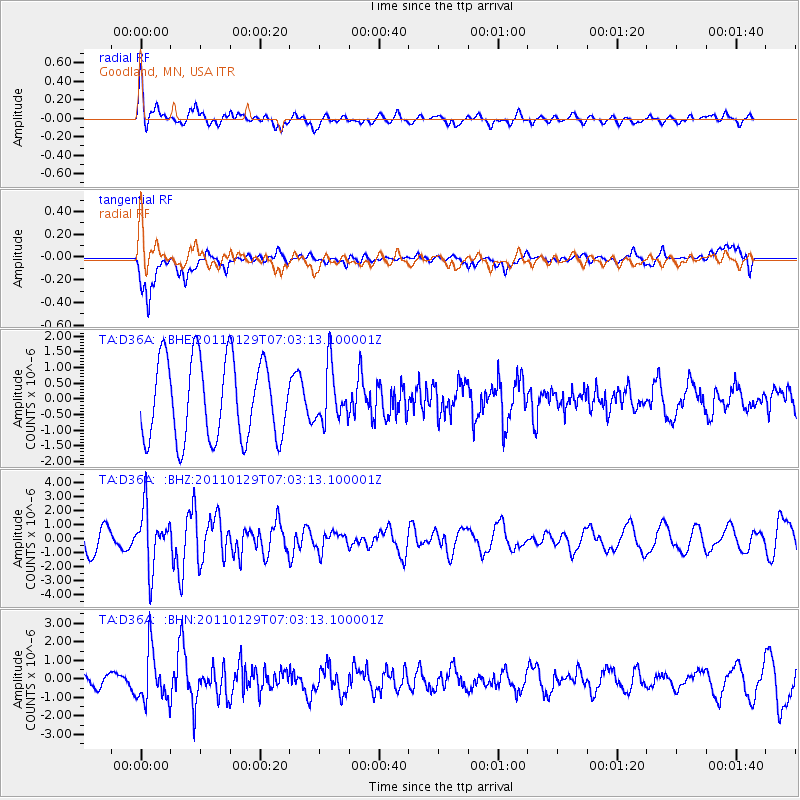
| Radial Match: |
80.11379 % |
| Radial Bump: |
384 |
| Transverse Match: |
70.259636 % |
| Transverse Bump: |
400 |
| SOD ConfigId: |
350818 |
| Insert Time: |
2011-07-20 09:36:10.933 +0000 |
| GWidth: |
2.5 |
| Max Bumps: |
400 |
| Tol: |
0.001 |
|
Signal To Noise
| Channel | StoN | STA | LTA |
| TA:D36A: :BHZ:20110129T07:03:13.100001Z | 1.7455605 | 2.0372124E-6 | 1.167082E-6 |
| TA:D36A: :BHN:20110129T07:03:13.100001Z | 2.5237243 | 1.3596451E-6 | 5.387455E-7 |
| TA:D36A: :BHE:20110129T07:03:13.100001Z | 0.674476 | 8.5865236E-7 | 1.2730658E-6 |
| Arrivals |
| Ps | 2.6 SECOND |
| PpPs | 9.2 SECOND |
| PsPs/PpSs | 12 SECOND |


