You are here: Home > Network List > TA - USArray Transportable Network (new EarthScope stations) Stations List
> Station G36A St. Michael, MN, USA > Earthquake Result Viewer
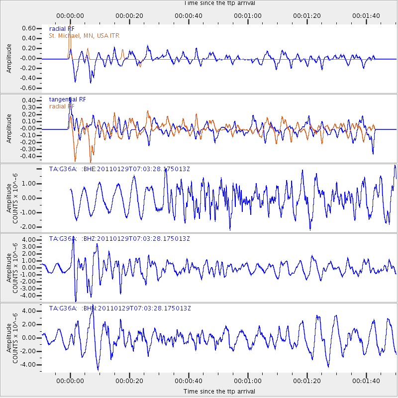
G36A St. Michael, MN, USA - Earthquake Result Viewer
*The percent match for this event was below the threshold and hence no stack was calculated.
| Earthquake location: |
Jan Mayen Island Region |
| Earthquake latitude/longitude: |
70.9/-6.7 |
| Earthquake time(UTC): |
2011/01/29 (029) 06:55:26 GMT |
| Earthquake Depth: |
6.0 km |
| Earthquake Magnitude: |
6.1 MB, 6.1 MS, 6.2 MW, 6.2 MW |
| Earthquake Catalog/Contributor: |
WHDF/NEIC |
|
| Network: |
TA USArray Transportable Network (new EarthScope stations) |
| Station: |
G36A St. Michael, MN, USA |
| Lat/Lon: |
45.23 N/93.75 W |
| Elevation: |
293 m |
|
| Distance: |
47.1 deg |
| Az: |
285.706 deg |
| Baz: |
26.595 deg |
| Ray Param: |
$rayparam |
*The percent match for this event was below the threshold and hence was not used in the summary stack. |
|
| Radial Match: |
56.900635 % |
| Radial Bump: |
400 |
| Transverse Match: |
56.021797 % |
| Transverse Bump: |
400 |
| SOD ConfigId: |
350818 |
| Insert Time: |
2011-07-20 09:39:16.809 +0000 |
| GWidth: |
2.5 |
| Max Bumps: |
400 |
| Tol: |
0.001 |
|
Signal To Noise
| Channel | StoN | STA | LTA |
| TA:G36A: :BHZ:20110129T07:03:28.175013Z | 2.8908067 | 2.0423436E-6 | 7.0649605E-7 |
| TA:G36A: :BHN:20110129T07:03:28.175013Z | 1.4626373 | 1.6050609E-6 | 1.0973745E-6 |
| TA:G36A: :BHE:20110129T07:03:28.175013Z | 1.1502942 | 9.317828E-7 | 8.100387E-7 |
| Arrivals |
| Ps | |
| PpPs | |
| PsPs/PpSs | |


