You are here: Home > Network List > US - United States National Seismic Network Stations List
> Station WUAZ Wupatki, Arizona, USA > Earthquake Result Viewer
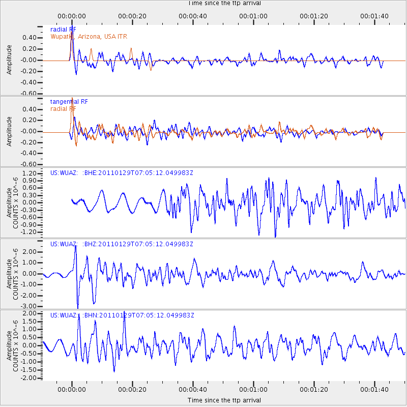
WUAZ Wupatki, Arizona, USA - Earthquake Result Viewer
*The percent match for this event was below the threshold and hence no stack was calculated.
| Earthquake location: |
Jan Mayen Island Region |
| Earthquake latitude/longitude: |
70.9/-6.7 |
| Earthquake time(UTC): |
2011/01/29 (029) 06:55:26 GMT |
| Earthquake Depth: |
6.0 km |
| Earthquake Magnitude: |
6.1 MB, 6.1 MS, 6.2 MW, 6.2 MW |
| Earthquake Catalog/Contributor: |
WHDF/NEIC |
|
| Network: |
US United States National Seismic Network |
| Station: |
WUAZ Wupatki, Arizona, USA |
| Lat/Lon: |
35.52 N/111.37 W |
| Elevation: |
1592 m |
|
| Distance: |
61.4 deg |
| Az: |
296.037 deg |
| Baz: |
21.218 deg |
| Ray Param: |
$rayparam |
*The percent match for this event was below the threshold and hence was not used in the summary stack. |
|
| Radial Match: |
77.74655 % |
| Radial Bump: |
400 |
| Transverse Match: |
76.777664 % |
| Transverse Bump: |
400 |
| SOD ConfigId: |
350818 |
| Insert Time: |
2011-07-20 10:02:22.876 +0000 |
| GWidth: |
2.5 |
| Max Bumps: |
400 |
| Tol: |
0.001 |
|
Signal To Noise
| Channel | StoN | STA | LTA |
| US:WUAZ: :BHZ:20110129T07:05:12.049983Z | 4.30888 | 1.2869024E-6 | 2.9866288E-7 |
| US:WUAZ: :BHN:20110129T07:05:12.049983Z | 4.0192275 | 7.4391346E-7 | 1.8508867E-7 |
| US:WUAZ: :BHE:20110129T07:05:12.049983Z | 1.5064557 | 3.6453037E-7 | 2.4197882E-7 |
| Arrivals |
| Ps | |
| PpPs | |
| PsPs/PpSs | |


