You are here: Home > Network List > UW - Pacific Northwest Regional Seismic Network Stations List
> Station YACT Amboy, WA, USA > Earthquake Result Viewer
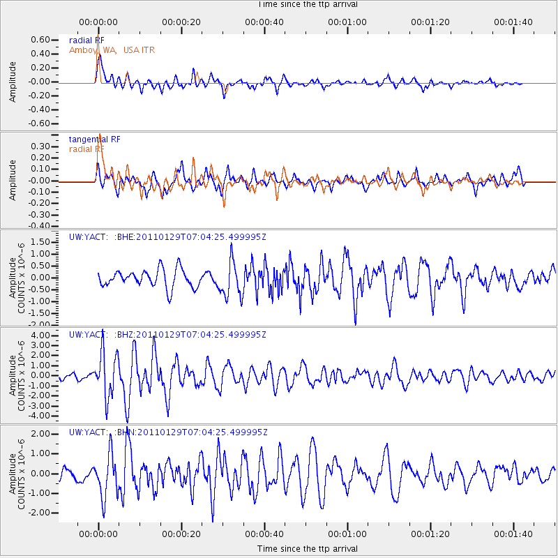
YACT Amboy, WA, USA - Earthquake Result Viewer
*The percent match for this event was below the threshold and hence no stack was calculated.
| Earthquake location: |
Jan Mayen Island Region |
| Earthquake latitude/longitude: |
70.9/-6.7 |
| Earthquake time(UTC): |
2011/01/29 (029) 06:55:26 GMT |
| Earthquake Depth: |
6.0 km |
| Earthquake Magnitude: |
6.1 MB, 6.1 MS, 6.2 MW, 6.2 MW |
| Earthquake Catalog/Contributor: |
WHDF/NEIC |
|
| Network: |
UW Pacific Northwest Regional Seismic Network |
| Station: |
YACT Amboy, WA, USA |
| Lat/Lon: |
45.93 N/122.42 W |
| Elevation: |
211 m |
|
| Distance: |
54.8 deg |
| Az: |
309.682 deg |
| Baz: |
21.244 deg |
| Ray Param: |
$rayparam |
*The percent match for this event was below the threshold and hence was not used in the summary stack. |
|
| Radial Match: |
78.40683 % |
| Radial Bump: |
400 |
| Transverse Match: |
73.76654 % |
| Transverse Bump: |
400 |
| SOD ConfigId: |
350818 |
| Insert Time: |
2011-07-20 10:11:32.861 +0000 |
| GWidth: |
2.5 |
| Max Bumps: |
400 |
| Tol: |
0.001 |
|
Signal To Noise
| Channel | StoN | STA | LTA |
| UW:YACT: :BHZ:20110129T07:04:25.499995Z | 6.3922772 | 2.2444517E-6 | 3.5111927E-7 |
| UW:YACT: :BHN:20110129T07:04:25.499995Z | 3.3651145 | 1.1054675E-6 | 3.2850815E-7 |
| UW:YACT: :BHE:20110129T07:04:25.499995Z | 2.028401 | 7.558897E-7 | 3.72653E-7 |
| Arrivals |
| Ps | |
| PpPs | |
| PsPs/PpSs | |


