You are here: Home > Network List > UW - Pacific Northwest Regional Seismic Network Stations List
> Station OMAK Colville Reservation, Omak, WA, USA > Earthquake Result Viewer
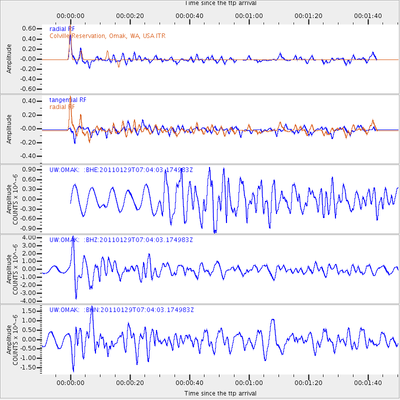
OMAK Colville Reservation, Omak, WA, USA - Earthquake Result Viewer
*The percent match for this event was below the threshold and hence no stack was calculated.
| Earthquake location: |
Jan Mayen Island Region |
| Earthquake latitude/longitude: |
70.9/-6.7 |
| Earthquake time(UTC): |
2011/01/29 (029) 06:55:26 GMT |
| Earthquake Depth: |
6.0 km |
| Earthquake Magnitude: |
6.1 MB, 6.1 MS, 6.2 MW, 6.2 MW |
| Earthquake Catalog/Contributor: |
WHDF/NEIC |
|
| Network: |
UW Pacific Northwest Regional Seismic Network |
| Station: |
OMAK Colville Reservation, Omak, WA, USA |
| Lat/Lon: |
48.36 N/119.33 W |
| Elevation: |
696 m |
|
| Distance: |
51.7 deg |
| Az: |
308.378 deg |
| Baz: |
22.719 deg |
| Ray Param: |
$rayparam |
*The percent match for this event was below the threshold and hence was not used in the summary stack. |
|
| Radial Match: |
77.3471 % |
| Radial Bump: |
382 |
| Transverse Match: |
60.68893 % |
| Transverse Bump: |
329 |
| SOD ConfigId: |
350818 |
| Insert Time: |
2011-07-20 10:12:00.022 +0000 |
| GWidth: |
2.5 |
| Max Bumps: |
400 |
| Tol: |
0.001 |
|
Signal To Noise
| Channel | StoN | STA | LTA |
| UW:OMAK: :BHZ:20110129T07:04:03.174983Z | 6.9066963 | 1.9078739E-6 | 2.762354E-7 |
| UW:OMAK: :BHN:20110129T07:04:03.174983Z | 3.223229 | 6.857311E-7 | 2.1274664E-7 |
| UW:OMAK: :BHE:20110129T07:04:03.174983Z | 1.80205 | 4.6247754E-7 | 2.5663968E-7 |
| Arrivals |
| Ps | |
| PpPs | |
| PsPs/PpSs | |


