You are here: Home > Network List > UW - Pacific Northwest Regional Seismic Network Stations List
> Station DAVN Chrisman Ranch, Davenport, WA, USA > Earthquake Result Viewer
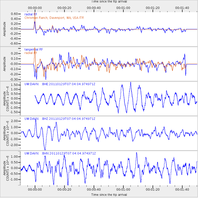
DAVN Chrisman Ranch, Davenport, WA, USA - Earthquake Result Viewer
*The percent match for this event was below the threshold and hence no stack was calculated.
| Earthquake location: |
Jan Mayen Island Region |
| Earthquake latitude/longitude: |
70.9/-6.7 |
| Earthquake time(UTC): |
2011/01/29 (029) 06:55:26 GMT |
| Earthquake Depth: |
6.0 km |
| Earthquake Magnitude: |
6.1 MB, 6.1 MS, 6.2 MW, 6.2 MW |
| Earthquake Catalog/Contributor: |
WHDF/NEIC |
|
| Network: |
UW Pacific Northwest Regional Seismic Network |
| Station: |
DAVN Chrisman Ranch, Davenport, WA, USA |
| Lat/Lon: |
47.80 N/118.27 W |
| Elevation: |
495 m |
|
| Distance: |
52.0 deg |
| Az: |
307.271 deg |
| Baz: |
22.821 deg |
| Ray Param: |
$rayparam |
*The percent match for this event was below the threshold and hence was not used in the summary stack. |
|
| Radial Match: |
62.598103 % |
| Radial Bump: |
400 |
| Transverse Match: |
61.725105 % |
| Transverse Bump: |
400 |
| SOD ConfigId: |
350818 |
| Insert Time: |
2011-07-20 10:13:29.377 +0000 |
| GWidth: |
2.5 |
| Max Bumps: |
400 |
| Tol: |
0.001 |
|
Signal To Noise
| Channel | StoN | STA | LTA |
| UW:DAVN: :BHZ:20110129T07:04:04.974971Z | 3.6509693 | 9.529075E-7 | 2.6100125E-7 |
| UW:DAVN: :BHN:20110129T07:04:04.974971Z | 2.7174437 | 4.7787313E-7 | 1.7585393E-7 |
| UW:DAVN: :BHE:20110129T07:04:04.974971Z | 1.418624 | 5.6095996E-7 | 3.954254E-7 |
| Arrivals |
| Ps | |
| PpPs | |
| PsPs/PpSs | |


