You are here: Home > Network List > AZ - ANZA Regional Network Stations List
> Station HWB AZ.HWB > Earthquake Result Viewer
HWB AZ.HWB - Earthquake Result Viewer
| Earthquake location: |
Solomon Islands |
| Earthquake latitude/longitude: |
-10.9/162.1 |
| Earthquake time(UTC): |
2007/11/27 (331) 11:49:58 GMT |
| Earthquake Depth: |
16 km |
| Earthquake Magnitude: |
5.9 MB, 6.7 MS, 6.6 MW, 6.4 MW |
| Earthquake Catalog/Contributor: |
WHDF/NEIC |
|
| Network: |
AZ ANZA Regional Network |
| Station: |
HWB AZ.HWB |
| Lat/Lon: |
33.03 N/116.96 W |
| Elevation: |
478 m |
|
| Distance: |
88.4 deg |
| Az: |
56.081 deg |
| Baz: |
255.938 deg |
| Ray Param: |
0.042617586 |
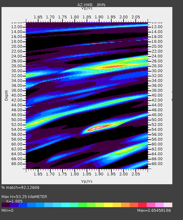
| Estimated Moho Depth: |
53.25 km |
| Estimated Crust Vp/Vs: |
1.88 |
| Assumed Crust Vp: |
6.264 km/s |
| Estimated Crust Vs: |
3.323 km/s |
| Estimated Crust Poisson's Ratio: |
0.30 |
|
| Radial Match: |
92.12686 % |
| Radial Bump: |
400 |
| Transverse Match: |
70.89535 % |
| Transverse Bump: |
400 |
| SOD ConfigId: |
2564 |
| Insert Time: |
2010-02-26 19:25:36.319 +0000 |
| GWidth: |
2.5 |
| Max Bumps: |
400 |
| Tol: |
0.001 |
|
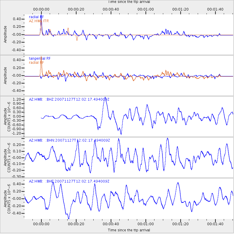
Signal To Noise
| Channel | StoN | STA | LTA |
| AZ:HWB: :BHN:20071127T12:02:17.494009Z | 0.7694053 | 3.817462E-8 | 4.9615746E-8 |
| AZ:HWB: :BHE:20071127T12:02:17.494009Z | 3.1772425 | 1.6021039E-7 | 5.042435E-8 |
| AZ:HWB: :BHZ:20071127T12:02:17.494009Z | 5.269731 | 4.618166E-7 | 8.7635705E-8 |
| Arrivals |
| Ps | 7.7 SECOND |
| PpPs | 24 SECOND |
| PsPs/PpSs | 32 SECOND |


