You are here: Home > Network List > TA - USArray Transportable Network (new EarthScope stations) Stations List
> Station O48A Farmland, IN, USA > Earthquake Result Viewer
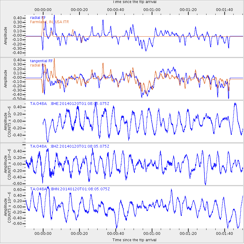
O48A Farmland, IN, USA - Earthquake Result Viewer
*The percent match for this event was below the threshold and hence no stack was calculated.
| Earthquake location: |
Kuril Islands |
| Earthquake latitude/longitude: |
46.4/153.4 |
| Earthquake time(UTC): |
2014/01/20 (020) 00:56:36 GMT |
| Earthquake Depth: |
43 km |
| Earthquake Magnitude: |
4.8 mb |
| Earthquake Catalog/Contributor: |
ISC/ISC |
|
| Network: |
TA USArray Transportable Network (new EarthScope stations) |
| Station: |
O48A Farmland, IN, USA |
| Lat/Lon: |
40.26 N/85.16 W |
| Elevation: |
300 m |
|
| Distance: |
79.1 deg |
| Az: |
41.691 deg |
| Baz: |
323.063 deg |
| Ray Param: |
$rayparam |
*The percent match for this event was below the threshold and hence was not used in the summary stack. |
|
| Radial Match: |
42.91241 % |
| Radial Bump: |
400 |
| Transverse Match: |
36.350403 % |
| Transverse Bump: |
400 |
| SOD ConfigId: |
3390531 |
| Insert Time: |
2019-04-10 01:25:56.022 +0000 |
| GWidth: |
2.5 |
| Max Bumps: |
400 |
| Tol: |
0.001 |
|
Signal To Noise
| Channel | StoN | STA | LTA |
| TA:O48A: :BHZ:20140120T01:08:05.075Z | 1.8240243 | 3.2049286E-7 | 1.7570646E-7 |
| TA:O48A: :BHN:20140120T01:08:05.075Z | 1.3210061 | 4.7998316E-7 | 3.6334666E-7 |
| TA:O48A: :BHE:20140120T01:08:05.075Z | 1.3759539 | 3.0542313E-7 | 2.2197192E-7 |
| Arrivals |
| Ps | |
| PpPs | |
| PsPs/PpSs | |


