You are here: Home > Network List > AZ - ANZA Regional Network Stations List
> Station LVA2 AZ.LVA2 > Earthquake Result Viewer
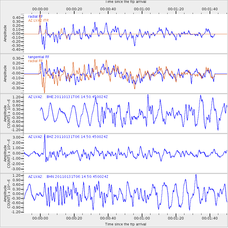
LVA2 AZ.LVA2 - Earthquake Result Viewer
*The percent match for this event was below the threshold and hence no stack was calculated.
| Earthquake location: |
Tonga Islands Region |
| Earthquake latitude/longitude: |
-22.0/-175.6 |
| Earthquake time(UTC): |
2011/01/31 (031) 06:03:27 GMT |
| Earthquake Depth: |
76 km |
| Earthquake Magnitude: |
6.0 MB, 6.0 MW, 6.0 MW |
| Earthquake Catalog/Contributor: |
WHDF/NEIC |
|
| Network: |
AZ ANZA Regional Network |
| Station: |
LVA2 AZ.LVA2 |
| Lat/Lon: |
33.35 N/116.56 W |
| Elevation: |
1435 m |
|
| Distance: |
78.7 deg |
| Az: |
47.056 deg |
| Baz: |
234.253 deg |
| Ray Param: |
$rayparam |
*The percent match for this event was below the threshold and hence was not used in the summary stack. |
|
| Radial Match: |
77.156876 % |
| Radial Bump: |
400 |
| Transverse Match: |
51.853477 % |
| Transverse Bump: |
400 |
| SOD ConfigId: |
350818 |
| Insert Time: |
2011-07-20 10:46:00.462 +0000 |
| GWidth: |
2.5 |
| Max Bumps: |
400 |
| Tol: |
0.001 |
|
Signal To Noise
| Channel | StoN | STA | LTA |
| AZ:LVA2: :BHZ:20110131T06:14:50.450024Z | 5.9934697 | 1.212799E-6 | 2.0235339E-7 |
| AZ:LVA2: :BHN:20110131T06:14:50.450024Z | 1.0875499 | 3.2828825E-7 | 3.018604E-7 |
| AZ:LVA2: :BHE:20110131T06:14:50.450024Z | 1.6152097 | 6.8706544E-7 | 4.253723E-7 |
| Arrivals |
| Ps | |
| PpPs | |
| PsPs/PpSs | |


