You are here: Home > Network List > AZ - ANZA Regional Network Stations List
> Station SMER AZ.SMER > Earthquake Result Viewer
SMER AZ.SMER - Earthquake Result Viewer
*The percent match for this event was below the threshold and hence no stack was calculated.
| Earthquake location: |
Tonga Islands Region |
| Earthquake latitude/longitude: |
-22.0/-175.6 |
| Earthquake time(UTC): |
2011/01/31 (031) 06:03:27 GMT |
| Earthquake Depth: |
76 km |
| Earthquake Magnitude: |
6.0 MB, 6.0 MW, 6.0 MW |
| Earthquake Catalog/Contributor: |
WHDF/NEIC |
|
| Network: |
AZ ANZA Regional Network |
| Station: |
SMER AZ.SMER |
| Lat/Lon: |
33.46 N/117.17 W |
| Elevation: |
355 m |
|
| Distance: |
78.4 deg |
| Az: |
46.664 deg |
| Baz: |
233.841 deg |
| Ray Param: |
$rayparam |
*The percent match for this event was below the threshold and hence was not used in the summary stack. |
|
| Radial Match: |
56.933346 % |
| Radial Bump: |
400 |
| Transverse Match: |
47.670616 % |
| Transverse Bump: |
400 |
| SOD ConfigId: |
350818 |
| Insert Time: |
2011-07-20 10:48:51.176 +0000 |
| GWidth: |
2.5 |
| Max Bumps: |
400 |
| Tol: |
0.001 |
|
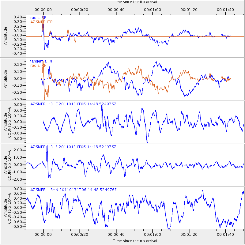
Signal To Noise
| Channel | StoN | STA | LTA |
| AZ:SMER: :BHZ:20110131T06:14:48.524976Z | 3.5461547 | 1.1392224E-6 | 3.2125567E-7 |
| AZ:SMER: :BHN:20110131T06:14:48.524976Z | 0.8589955 | 3.183339E-7 | 3.7058854E-7 |
| AZ:SMER: :BHE:20110131T06:14:48.524976Z | 1.1362313 | 3.5328287E-7 | 3.1092515E-7 |
| Arrivals |
| Ps | |
| PpPs | |
| PsPs/PpSs | |


