You are here: Home > Network List > CI - Caltech Regional Seismic Network Stations List
> Station FUR Furnace Creek, CA, USA > Earthquake Result Viewer
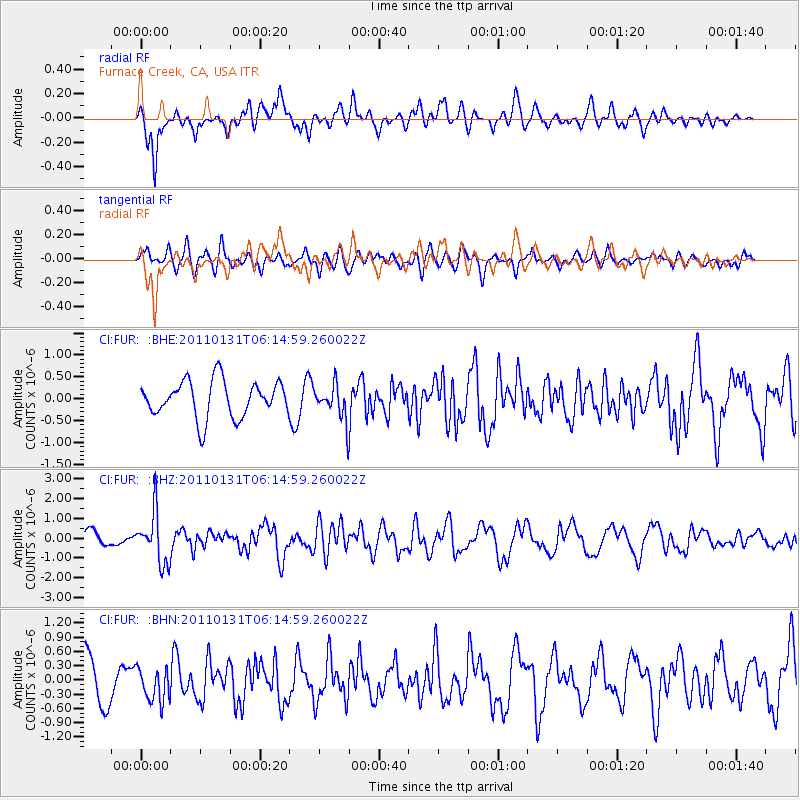
FUR Furnace Creek, CA, USA - Earthquake Result Viewer
*The percent match for this event was below the threshold and hence no stack was calculated.
| Earthquake location: |
Tonga Islands Region |
| Earthquake latitude/longitude: |
-22.0/-175.6 |
| Earthquake time(UTC): |
2011/01/31 (031) 06:03:27 GMT |
| Earthquake Depth: |
76 km |
| Earthquake Magnitude: |
6.0 MB, 6.0 MW, 6.0 MW |
| Earthquake Catalog/Contributor: |
WHDF/NEIC |
|
| Network: |
CI Caltech Regional Seismic Network |
| Station: |
FUR Furnace Creek, CA, USA |
| Lat/Lon: |
36.47 N/116.86 W |
| Elevation: |
-37.0 m |
|
| Distance: |
80.4 deg |
| Az: |
44.354 deg |
| Baz: |
233.59 deg |
| Ray Param: |
$rayparam |
*The percent match for this event was below the threshold and hence was not used in the summary stack. |
|
| Radial Match: |
73.68041 % |
| Radial Bump: |
400 |
| Transverse Match: |
49.100662 % |
| Transverse Bump: |
400 |
| SOD ConfigId: |
350818 |
| Insert Time: |
2011-07-20 11:01:59.658 +0000 |
| GWidth: |
2.5 |
| Max Bumps: |
400 |
| Tol: |
0.001 |
|
Signal To Noise
| Channel | StoN | STA | LTA |
| CI:FUR: :BHZ:20110131T06:14:59.260022Z | 3.1143453 | 1.2838951E-6 | 4.1225204E-7 |
| CI:FUR: :BHN:20110131T06:14:59.260022Z | 0.8391986 | 3.5169145E-7 | 4.1908012E-7 |
| CI:FUR: :BHE:20110131T06:14:59.260022Z | 0.96854496 | 4.0231396E-7 | 4.1537976E-7 |
| Arrivals |
| Ps | |
| PpPs | |
| PsPs/PpSs | |


