You are here: Home > Network List > CI - Caltech Regional Seismic Network Stations List
> Station MPM Manuel Prospect Mine, California, USA > Earthquake Result Viewer
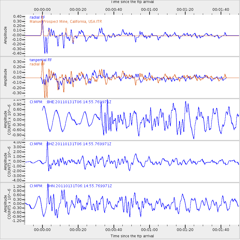
MPM Manuel Prospect Mine, California, USA - Earthquake Result Viewer
*The percent match for this event was below the threshold and hence no stack was calculated.
| Earthquake location: |
Tonga Islands Region |
| Earthquake latitude/longitude: |
-22.0/-175.6 |
| Earthquake time(UTC): |
2011/01/31 (031) 06:03:27 GMT |
| Earthquake Depth: |
76 km |
| Earthquake Magnitude: |
6.0 MB, 6.0 MW, 6.0 MW |
| Earthquake Catalog/Contributor: |
WHDF/NEIC |
|
| Network: |
CI Caltech Regional Seismic Network |
| Station: |
MPM Manuel Prospect Mine, California, USA |
| Lat/Lon: |
36.06 N/117.49 W |
| Elevation: |
185 m |
|
| Distance: |
79.7 deg |
| Az: |
44.38 deg |
| Baz: |
233.227 deg |
| Ray Param: |
$rayparam |
*The percent match for this event was below the threshold and hence was not used in the summary stack. |
|
| Radial Match: |
65.780594 % |
| Radial Bump: |
400 |
| Transverse Match: |
42.03405 % |
| Transverse Bump: |
400 |
| SOD ConfigId: |
350818 |
| Insert Time: |
2011-07-20 11:04:14.649 +0000 |
| GWidth: |
2.5 |
| Max Bumps: |
400 |
| Tol: |
0.001 |
|
Signal To Noise
| Channel | StoN | STA | LTA |
| CI:MPM: :BHZ:20110131T06:14:55.769971Z | 9.8648205 | 1.3690509E-6 | 1.3878112E-7 |
| CI:MPM: :BHN:20110131T06:14:55.769971Z | 2.5847588 | 6.125671E-7 | 2.3699197E-7 |
| CI:MPM: :BHE:20110131T06:14:55.769971Z | 1.0666465 | 4.222347E-7 | 3.9585254E-7 |
| Arrivals |
| Ps | |
| PpPs | |
| PsPs/PpSs | |


