You are here: Home > Network List > CI - Caltech Regional Seismic Network Stations List
> Station RCT Rector, Visalia, CA, USA > Earthquake Result Viewer
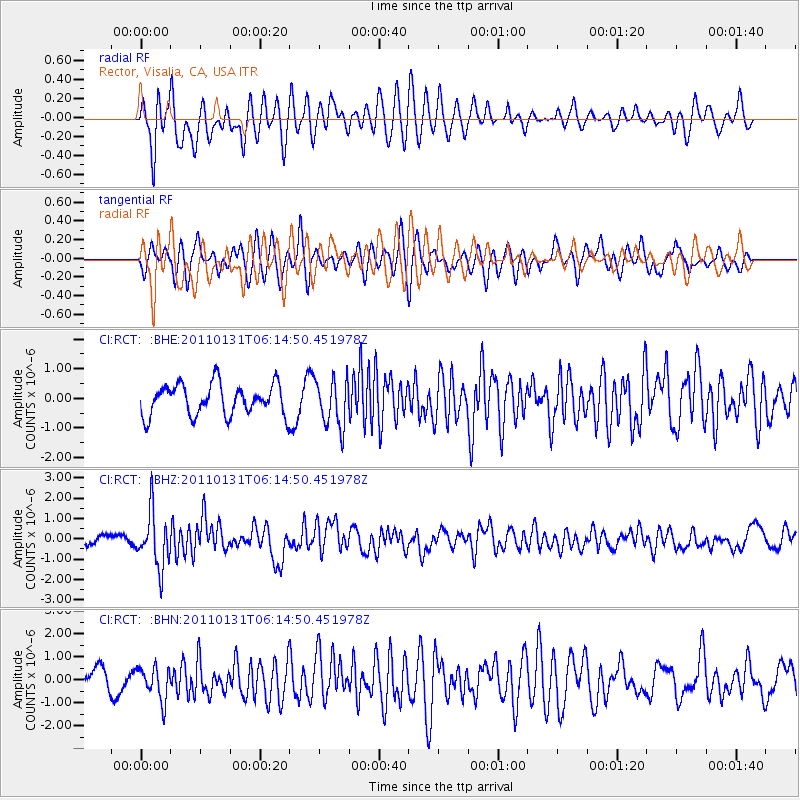
RCT Rector, Visalia, CA, USA - Earthquake Result Viewer
*The percent match for this event was below the threshold and hence no stack was calculated.
| Earthquake location: |
Tonga Islands Region |
| Earthquake latitude/longitude: |
-22.0/-175.6 |
| Earthquake time(UTC): |
2011/01/31 (031) 06:03:27 GMT |
| Earthquake Depth: |
76 km |
| Earthquake Magnitude: |
6.0 MB, 6.0 MW, 6.0 MW |
| Earthquake Catalog/Contributor: |
WHDF/NEIC |
|
| Network: |
CI Caltech Regional Seismic Network |
| Station: |
RCT Rector, Visalia, CA, USA |
| Lat/Lon: |
36.31 N/119.24 W |
| Elevation: |
107 m |
|
| Distance: |
78.7 deg |
| Az: |
43.303 deg |
| Baz: |
231.994 deg |
| Ray Param: |
$rayparam |
*The percent match for this event was below the threshold and hence was not used in the summary stack. |
|
| Radial Match: |
64.46156 % |
| Radial Bump: |
400 |
| Transverse Match: |
70.54618 % |
| Transverse Bump: |
400 |
| SOD ConfigId: |
350818 |
| Insert Time: |
2011-07-20 11:08:05.795 +0000 |
| GWidth: |
2.5 |
| Max Bumps: |
400 |
| Tol: |
0.001 |
|
Signal To Noise
| Channel | StoN | STA | LTA |
| CI:RCT: :BHZ:20110131T06:14:50.451978Z | 6.9268603 | 1.3480002E-6 | 1.9460478E-7 |
| CI:RCT: :BHN:20110131T06:14:50.451978Z | 1.5784314 | 7.08959E-7 | 4.4915416E-7 |
| CI:RCT: :BHE:20110131T06:14:50.451978Z | 1.5208722 | 7.961398E-7 | 5.2347576E-7 |
| Arrivals |
| Ps | |
| PpPs | |
| PsPs/PpSs | |


