You are here: Home > Network List > CI - Caltech Regional Seismic Network Stations List
> Station SMM Simmler, CA, USA > Earthquake Result Viewer
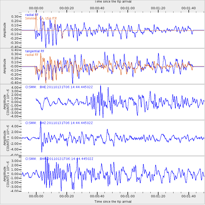
SMM Simmler, CA, USA - Earthquake Result Viewer
*The percent match for this event was below the threshold and hence no stack was calculated.
| Earthquake location: |
Tonga Islands Region |
| Earthquake latitude/longitude: |
-22.0/-175.6 |
| Earthquake time(UTC): |
2011/01/31 (031) 06:03:27 GMT |
| Earthquake Depth: |
76 km |
| Earthquake Magnitude: |
6.0 MB, 6.0 MW, 6.0 MW |
| Earthquake Catalog/Contributor: |
WHDF/NEIC |
|
| Network: |
CI Caltech Regional Seismic Network |
| Station: |
SMM Simmler, CA, USA |
| Lat/Lon: |
35.31 N/120.00 W |
| Elevation: |
599 m |
|
| Distance: |
77.6 deg |
| Az: |
43.711 deg |
| Baz: |
231.639 deg |
| Ray Param: |
$rayparam |
*The percent match for this event was below the threshold and hence was not used in the summary stack. |
|
| Radial Match: |
69.27955 % |
| Radial Bump: |
400 |
| Transverse Match: |
50.73214 % |
| Transverse Bump: |
400 |
| SOD ConfigId: |
350818 |
| Insert Time: |
2011-07-20 11:08:35.778 +0000 |
| GWidth: |
2.5 |
| Max Bumps: |
400 |
| Tol: |
0.001 |
|
Signal To Noise
| Channel | StoN | STA | LTA |
| CI:SMM: :BHZ:20110131T06:14:44.44502Z | 5.117862 | 2.1913972E-6 | 4.2818607E-7 |
| CI:SMM: :BHN:20110131T06:14:44.44502Z | 0.86935586 | 6.304141E-7 | 7.2515076E-7 |
| CI:SMM: :BHE:20110131T06:14:44.44502Z | 0.79920983 | 5.8434557E-7 | 7.311541E-7 |
| Arrivals |
| Ps | |
| PpPs | |
| PsPs/PpSs | |


