You are here: Home > Network List > TA - USArray Transportable Network (new EarthScope stations) Stations List
> Station M04C Macdoel, CA, USA > Earthquake Result Viewer
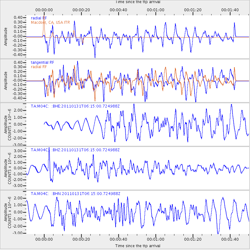
M04C Macdoel, CA, USA - Earthquake Result Viewer
*The percent match for this event was below the threshold and hence no stack was calculated.
| Earthquake location: |
Tonga Islands Region |
| Earthquake latitude/longitude: |
-22.0/-175.6 |
| Earthquake time(UTC): |
2011/01/31 (031) 06:03:27 GMT |
| Earthquake Depth: |
76 km |
| Earthquake Magnitude: |
6.0 MB, 6.0 MW, 6.0 MW |
| Earthquake Catalog/Contributor: |
WHDF/NEIC |
|
| Network: |
TA USArray Transportable Network (new EarthScope stations) |
| Station: |
M04C Macdoel, CA, USA |
| Lat/Lon: |
41.78 N/121.84 W |
| Elevation: |
1391 m |
|
| Distance: |
80.6 deg |
| Az: |
37.701 deg |
| Baz: |
229.359 deg |
| Ray Param: |
$rayparam |
*The percent match for this event was below the threshold and hence was not used in the summary stack. |
|
| Radial Match: |
70.12598 % |
| Radial Bump: |
400 |
| Transverse Match: |
60.031815 % |
| Transverse Bump: |
400 |
| SOD ConfigId: |
350818 |
| Insert Time: |
2011-07-20 11:44:48.598 +0000 |
| GWidth: |
2.5 |
| Max Bumps: |
400 |
| Tol: |
0.001 |
|
Signal To Noise
| Channel | StoN | STA | LTA |
| TA:M04C: :BHZ:20110131T06:15:00.724988Z | 2.45239 | 1.4784532E-6 | 6.028622E-7 |
| TA:M04C: :BHN:20110131T06:15:00.724988Z | 0.7889583 | 9.640182E-7 | 1.2218875E-6 |
| TA:M04C: :BHE:20110131T06:15:00.724988Z | 2.6643033 | 1.1601247E-6 | 4.354327E-7 |
| Arrivals |
| Ps | |
| PpPs | |
| PsPs/PpSs | |


