You are here: Home > Network List > TA - USArray Transportable Network (new EarthScope stations) Stations List
> Station Q24A Divide, CO, USA > Earthquake Result Viewer
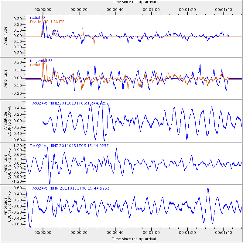
Q24A Divide, CO, USA - Earthquake Result Viewer
*The percent match for this event was below the threshold and hence no stack was calculated.
| Earthquake location: |
Tonga Islands Region |
| Earthquake latitude/longitude: |
-22.0/-175.6 |
| Earthquake time(UTC): |
2011/01/31 (031) 06:03:27 GMT |
| Earthquake Depth: |
76 km |
| Earthquake Magnitude: |
6.0 MB, 6.0 MW, 6.0 MW |
| Earthquake Catalog/Contributor: |
WHDF/NEIC |
|
| Network: |
TA USArray Transportable Network (new EarthScope stations) |
| Station: |
Q24A Divide, CO, USA |
| Lat/Lon: |
38.96 N/105.15 W |
| Elevation: |
2775 m |
|
| Distance: |
89.5 deg |
| Az: |
47.289 deg |
| Baz: |
241.004 deg |
| Ray Param: |
$rayparam |
*The percent match for this event was below the threshold and hence was not used in the summary stack. |
|
| Radial Match: |
42.483498 % |
| Radial Bump: |
334 |
| Transverse Match: |
59.85051 % |
| Transverse Bump: |
337 |
| SOD ConfigId: |
350818 |
| Insert Time: |
2011-07-20 11:49:33.404 +0000 |
| GWidth: |
2.5 |
| Max Bumps: |
400 |
| Tol: |
0.001 |
|
Signal To Noise
| Channel | StoN | STA | LTA |
| TA:Q24A: :BHZ:20110131T06:15:44.925Z | 2.0869353 | 6.6354875E-7 | 3.179537E-7 |
| TA:Q24A: :BHN:20110131T06:15:44.925Z | 0.8060591 | 2.0470388E-7 | 2.5395642E-7 |
| TA:Q24A: :BHE:20110131T06:15:44.925Z | 2.1290703 | 4.4935035E-7 | 2.1105474E-7 |
| Arrivals |
| Ps | |
| PpPs | |
| PsPs/PpSs | |


