You are here: Home > Network List > TA - USArray Transportable Network (new EarthScope stations) Stations List
> Station S31A Mullinville, KS, USA > Earthquake Result Viewer
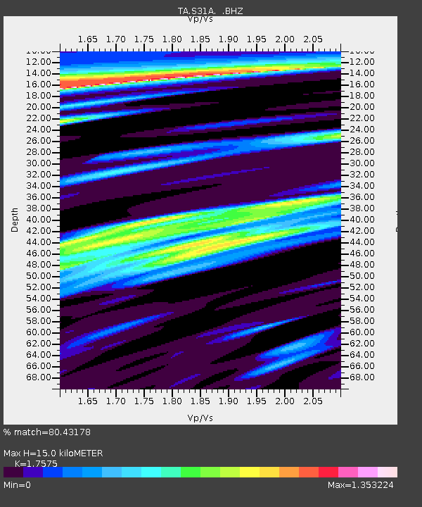
S31A Mullinville, KS, USA - Earthquake Result Viewer
| Earthquake location: |
Tonga Islands Region |
| Earthquake latitude/longitude: |
-22.0/-175.6 |
| Earthquake time(UTC): |
2011/01/31 (031) 06:03:27 GMT |
| Earthquake Depth: |
76 km |
| Earthquake Magnitude: |
6.0 MB, 6.0 MW, 6.0 MW |
| Earthquake Catalog/Contributor: |
WHDF/NEIC |
|
| Network: |
TA USArray Transportable Network (new EarthScope stations) |
| Station: |
S31A Mullinville, KS, USA |
| Lat/Lon: |
37.62 N/99.48 W |
| Elevation: |
700 m |
|
| Distance: |
92.9 deg |
| Az: |
50.524 deg |
| Baz: |
244.434 deg |
| Ray Param: |
0.041336592 |
| Estimated Moho Depth: |
15.0 km |
| Estimated Crust Vp/Vs: |
1.76 |
| Assumed Crust Vp: |
6.426 km/s |
| Estimated Crust Vs: |
3.656 km/s |
| Estimated Crust Poisson's Ratio: |
0.26 |
|
| Radial Match: |
80.43178 % |
| Radial Bump: |
400 |
| Transverse Match: |
60.16727 % |
| Transverse Bump: |
400 |
| SOD ConfigId: |
350818 |
| Insert Time: |
2011-07-20 12:03:32.035 +0000 |
| GWidth: |
2.5 |
| Max Bumps: |
400 |
| Tol: |
0.001 |
|

Signal To Noise
| Channel | StoN | STA | LTA |
| TA:S31A: :BHZ:20110131T06:16:00.375012Z | 4.001149 | 1.02176E-6 | 2.5536661E-7 |
| TA:S31A: :BHN:20110131T06:16:00.375012Z | 1.605465 | 5.093676E-7 | 3.172711E-7 |
| TA:S31A: :BHE:20110131T06:16:00.375012Z | 1.1813118 | 4.5008525E-7 | 3.8100458E-7 |
| Arrivals |
| Ps | 1.8 SECOND |
| PpPs | 6.3 SECOND |
| PsPs/PpSs | 8.1 SECOND |


