You are here: Home > Network List > TA - USArray Transportable Network (new EarthScope stations) Stations List
> Station P28A Satin Francis, KS, USA > Earthquake Result Viewer
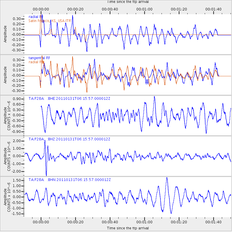
P28A Satin Francis, KS, USA - Earthquake Result Viewer
*The percent match for this event was below the threshold and hence no stack was calculated.
| Earthquake location: |
Tonga Islands Region |
| Earthquake latitude/longitude: |
-22.0/-175.6 |
| Earthquake time(UTC): |
2011/01/31 (031) 06:03:27 GMT |
| Earthquake Depth: |
76 km |
| Earthquake Magnitude: |
6.0 MB, 6.0 MW, 6.0 MW |
| Earthquake Catalog/Contributor: |
WHDF/NEIC |
|
| Network: |
TA USArray Transportable Network (new EarthScope stations) |
| Station: |
P28A Satin Francis, KS, USA |
| Lat/Lon: |
39.57 N/101.75 W |
| Elevation: |
1105 m |
|
| Distance: |
92.1 deg |
| Az: |
47.986 deg |
| Baz: |
243.134 deg |
| Ray Param: |
$rayparam |
*The percent match for this event was below the threshold and hence was not used in the summary stack. |
|
| Radial Match: |
77.42099 % |
| Radial Bump: |
400 |
| Transverse Match: |
59.583366 % |
| Transverse Bump: |
398 |
| SOD ConfigId: |
350818 |
| Insert Time: |
2011-07-20 12:04:49.848 +0000 |
| GWidth: |
2.5 |
| Max Bumps: |
400 |
| Tol: |
0.001 |
|
Signal To Noise
| Channel | StoN | STA | LTA |
| TA:P28A: :BHZ:20110131T06:15:57.000012Z | 4.1662936 | 9.943453E-7 | 2.3866423E-7 |
| TA:P28A: :BHN:20110131T06:15:57.000012Z | 1.2871909 | 4.438099E-7 | 3.4478953E-7 |
| TA:P28A: :BHE:20110131T06:15:57.000012Z | 1.1605718 | 3.9601994E-7 | 3.4122831E-7 |
| Arrivals |
| Ps | |
| PpPs | |
| PsPs/PpSs | |


