You are here: Home > Network List > TA - USArray Transportable Network (new EarthScope stations) Stations List
> Station N29A Votaw Ranch, Wellfleet, NE, USA > Earthquake Result Viewer
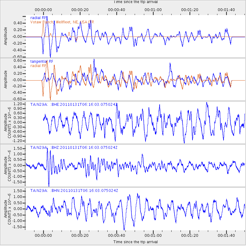
N29A Votaw Ranch, Wellfleet, NE, USA - Earthquake Result Viewer
*The percent match for this event was below the threshold and hence no stack was calculated.
| Earthquake location: |
Tonga Islands Region |
| Earthquake latitude/longitude: |
-22.0/-175.6 |
| Earthquake time(UTC): |
2011/01/31 (031) 06:03:27 GMT |
| Earthquake Depth: |
76 km |
| Earthquake Magnitude: |
6.0 MB, 6.0 MW, 6.0 MW |
| Earthquake Catalog/Contributor: |
WHDF/NEIC |
|
| Network: |
TA USArray Transportable Network (new EarthScope stations) |
| Station: |
N29A Votaw Ranch, Wellfleet, NE, USA |
| Lat/Lon: |
40.82 N/100.63 W |
| Elevation: |
897 m |
|
| Distance: |
93.5 deg |
| Az: |
47.257 deg |
| Baz: |
243.895 deg |
| Ray Param: |
$rayparam |
*The percent match for this event was below the threshold and hence was not used in the summary stack. |
|
| Radial Match: |
61.953857 % |
| Radial Bump: |
400 |
| Transverse Match: |
42.436123 % |
| Transverse Bump: |
396 |
| SOD ConfigId: |
350818 |
| Insert Time: |
2011-07-20 12:09:20.412 +0000 |
| GWidth: |
2.5 |
| Max Bumps: |
400 |
| Tol: |
0.001 |
|
Signal To Noise
| Channel | StoN | STA | LTA |
| TA:N29A: :BHZ:20110131T06:16:03.075024Z | 4.9472957 | 7.823781E-7 | 1.5814258E-7 |
| TA:N29A: :BHN:20110131T06:16:03.075024Z | 0.49838847 | 2.5549298E-7 | 5.126382E-7 |
| TA:N29A: :BHE:20110131T06:16:03.075024Z | 0.98278576 | 4.0230768E-7 | 4.0935439E-7 |
| Arrivals |
| Ps | |
| PpPs | |
| PsPs/PpSs | |


