You are here: Home > Network List > TA - USArray Transportable Network (new EarthScope stations) Stations List
> Station E25A Miller Ranch, Amidon, ND, USA > Earthquake Result Viewer
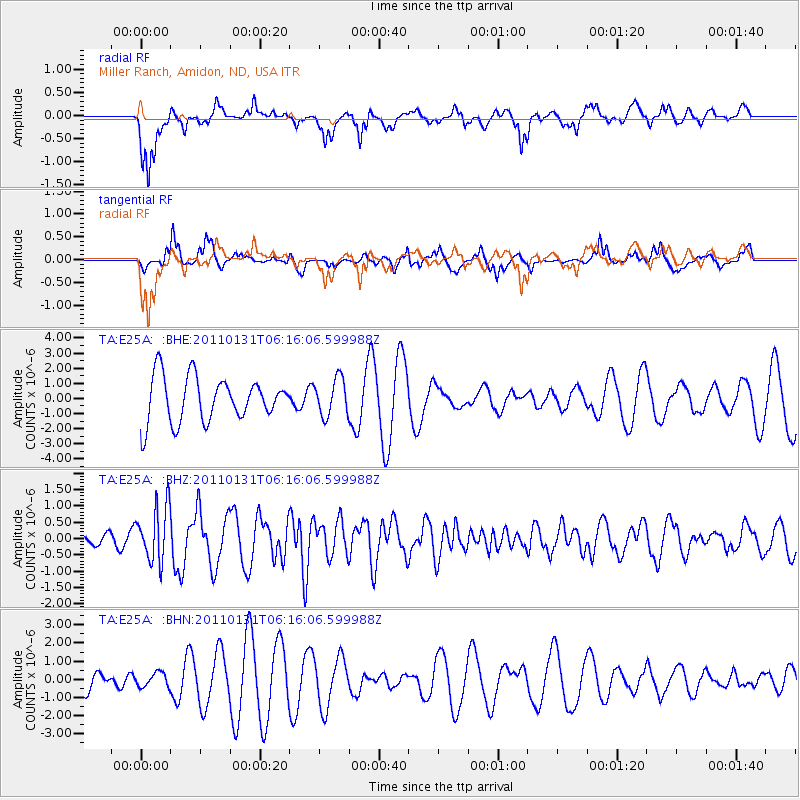
E25A Miller Ranch, Amidon, ND, USA - Earthquake Result Viewer
*The percent match for this event was below the threshold and hence no stack was calculated.
| Earthquake location: |
Tonga Islands Region |
| Earthquake latitude/longitude: |
-22.0/-175.6 |
| Earthquake time(UTC): |
2011/01/31 (031) 06:03:27 GMT |
| Earthquake Depth: |
76 km |
| Earthquake Magnitude: |
6.0 MB, 6.0 MW, 6.0 MW |
| Earthquake Catalog/Contributor: |
WHDF/NEIC |
|
| Network: |
TA USArray Transportable Network (new EarthScope stations) |
| Station: |
E25A Miller Ranch, Amidon, ND, USA |
| Lat/Lon: |
46.50 N/103.40 W |
| Elevation: |
885 m |
|
| Distance: |
94.2 deg |
| Az: |
41.267 deg |
| Baz: |
242.385 deg |
| Ray Param: |
$rayparam |
*The percent match for this event was below the threshold and hence was not used in the summary stack. |
|
| Radial Match: |
80.592766 % |
| Radial Bump: |
400 |
| Transverse Match: |
68.13086 % |
| Transverse Bump: |
400 |
| SOD ConfigId: |
350818 |
| Insert Time: |
2011-07-20 12:13:02.584 +0000 |
| GWidth: |
2.5 |
| Max Bumps: |
400 |
| Tol: |
0.001 |
|
Signal To Noise
| Channel | StoN | STA | LTA |
| TA:E25A: :BHZ:20110131T06:16:06.599988Z | 2.038003 | 8.453504E-7 | 4.1479353E-7 |
| TA:E25A: :BHN:20110131T06:16:06.599988Z | 0.7325807 | 3.9536445E-7 | 5.396872E-7 |
| TA:E25A: :BHE:20110131T06:16:06.599988Z | 0.83534855 | 1.2297695E-6 | 1.4721634E-6 |
| Arrivals |
| Ps | |
| PpPs | |
| PsPs/PpSs | |


