You are here: Home > Network List > TA - USArray Transportable Network (new EarthScope stations) Stations List
> Station J27A Elkhorn Farm, Martin, SD, USA > Earthquake Result Viewer
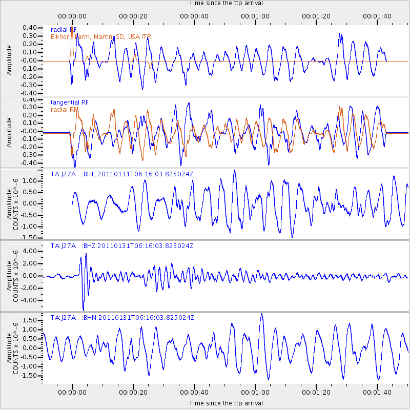
J27A Elkhorn Farm, Martin, SD, USA - Earthquake Result Viewer
*The percent match for this event was below the threshold and hence no stack was calculated.
| Earthquake location: |
Tonga Islands Region |
| Earthquake latitude/longitude: |
-22.0/-175.6 |
| Earthquake time(UTC): |
2011/01/31 (031) 06:03:27 GMT |
| Earthquake Depth: |
76 km |
| Earthquake Magnitude: |
6.0 MB, 6.0 MW, 6.0 MW |
| Earthquake Catalog/Contributor: |
WHDF/NEIC |
|
| Network: |
TA USArray Transportable Network (new EarthScope stations) |
| Station: |
J27A Elkhorn Farm, Martin, SD, USA |
| Lat/Lon: |
43.25 N/102.01 W |
| Elevation: |
1081 m |
|
| Distance: |
93.6 deg |
| Az: |
44.617 deg |
| Baz: |
243.137 deg |
| Ray Param: |
$rayparam |
*The percent match for this event was below the threshold and hence was not used in the summary stack. |
|
| Radial Match: |
57.818127 % |
| Radial Bump: |
400 |
| Transverse Match: |
63.654892 % |
| Transverse Bump: |
400 |
| SOD ConfigId: |
350818 |
| Insert Time: |
2011-07-20 12:19:34.508 +0000 |
| GWidth: |
2.5 |
| Max Bumps: |
400 |
| Tol: |
0.001 |
|
Signal To Noise
| Channel | StoN | STA | LTA |
| TA:J27A: :BHZ:20110131T06:16:03.825024Z | 13.25116 | 2.027916E-6 | 1.5303688E-7 |
| TA:J27A: :BHN:20110131T06:16:03.825024Z | 0.7462892 | 4.6401925E-7 | 6.217687E-7 |
| TA:J27A: :BHE:20110131T06:16:03.825024Z | 0.8174568 | 3.8472126E-7 | 4.7063193E-7 |
| Arrivals |
| Ps | |
| PpPs | |
| PsPs/PpSs | |


