You are here: Home > Network List > AZ - ANZA Regional Network Stations List
> Station HWB AZ.HWB > Earthquake Result Viewer
HWB AZ.HWB - Earthquake Result Viewer
| Earthquake location: |
Near S. Coast Of Honshu, Japan |
| Earthquake latitude/longitude: |
33.2/137.9 |
| Earthquake time(UTC): |
2009/08/09 (221) 10:55:55 GMT |
| Earthquake Depth: |
297 km |
| Earthquake Magnitude: |
6.5 MB, 7.1 MW, 7.1 MW |
| Earthquake Catalog/Contributor: |
WHDF/NEIC |
|
| Network: |
AZ ANZA Regional Network |
| Station: |
HWB AZ.HWB |
| Lat/Lon: |
33.03 N/116.96 W |
| Elevation: |
478 m |
|
| Distance: |
83.6 deg |
| Az: |
54.706 deg |
| Baz: |
305.422 deg |
| Ray Param: |
0.04533013 |
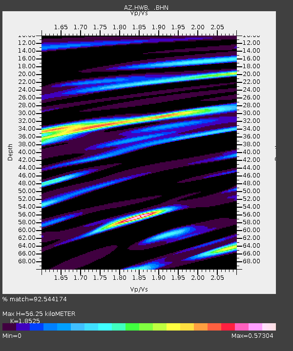
| Estimated Moho Depth: |
56.25 km |
| Estimated Crust Vp/Vs: |
1.85 |
| Assumed Crust Vp: |
6.264 km/s |
| Estimated Crust Vs: |
3.381 km/s |
| Estimated Crust Poisson's Ratio: |
0.29 |
|
| Radial Match: |
92.544174 % |
| Radial Bump: |
400 |
| Transverse Match: |
76.51921 % |
| Transverse Bump: |
400 |
| SOD ConfigId: |
2622 |
| Insert Time: |
2010-02-26 19:26:13.630 +0000 |
| GWidth: |
2.5 |
| Max Bumps: |
400 |
| Tol: |
0.001 |
|

Signal To Noise
| Channel | StoN | STA | LTA |
| AZ:HWB: :BHN:20090809T11:07:19.610Z | 90.63921 | 2.5457384E-6 | 2.8086502E-8 |
| AZ:HWB: :BHE:20090809T11:07:19.610Z | 11.709267 | 5.771917E-7 | 4.9293583E-8 |
| AZ:HWB: :BHZ:20090809T11:07:19.610Z | 18.820005 | 8.493743E-7 | 4.513146E-8 |
| Arrivals |
| Ps | 7.8 SECOND |
| PpPs | 25 SECOND |
| PsPs/PpSs | 33 SECOND |


