You are here: Home > Network List > TA - USArray Transportable Network (new EarthScope stations) Stations List
> Station S32A Newby Ranch, Pratt, KS, USA > Earthquake Result Viewer
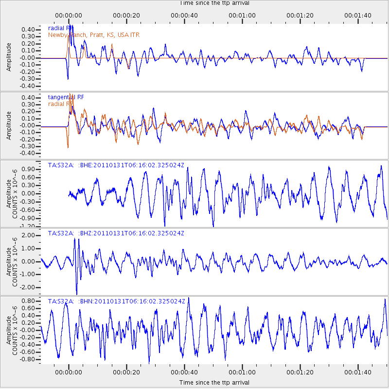
S32A Newby Ranch, Pratt, KS, USA - Earthquake Result Viewer
*The percent match for this event was below the threshold and hence no stack was calculated.
| Earthquake location: |
Tonga Islands Region |
| Earthquake latitude/longitude: |
-22.0/-175.6 |
| Earthquake time(UTC): |
2011/01/31 (031) 06:03:27 GMT |
| Earthquake Depth: |
76 km |
| Earthquake Magnitude: |
6.0 MB, 6.0 MW, 6.0 MW |
| Earthquake Catalog/Contributor: |
WHDF/NEIC |
|
| Network: |
TA USArray Transportable Network (new EarthScope stations) |
| Station: |
S32A Newby Ranch, Pratt, KS, USA |
| Lat/Lon: |
37.70 N/98.94 W |
| Elevation: |
558 m |
|
| Distance: |
93.3 deg |
| Az: |
50.638 deg |
| Baz: |
244.762 deg |
| Ray Param: |
$rayparam |
*The percent match for this event was below the threshold and hence was not used in the summary stack. |
|
| Radial Match: |
71.82878 % |
| Radial Bump: |
400 |
| Transverse Match: |
45.77554 % |
| Transverse Bump: |
400 |
| SOD ConfigId: |
350818 |
| Insert Time: |
2011-07-20 12:28:08.715 +0000 |
| GWidth: |
2.5 |
| Max Bumps: |
400 |
| Tol: |
0.001 |
|
Signal To Noise
| Channel | StoN | STA | LTA |
| TA:S32A: :BHZ:20110131T06:16:02.325024Z | 4.923047 | 9.898664E-7 | 2.0106783E-7 |
| TA:S32A: :BHN:20110131T06:16:02.325024Z | 1.5801992 | 4.2676152E-7 | 2.7006817E-7 |
| TA:S32A: :BHE:20110131T06:16:02.325024Z | 1.711718 | 5.211872E-7 | 3.0448194E-7 |
| Arrivals |
| Ps | |
| PpPs | |
| PsPs/PpSs | |


