You are here: Home > Network List > TA - USArray Transportable Network (new EarthScope stations) Stations List
> Station T25A Trinidad, CO, USA > Earthquake Result Viewer
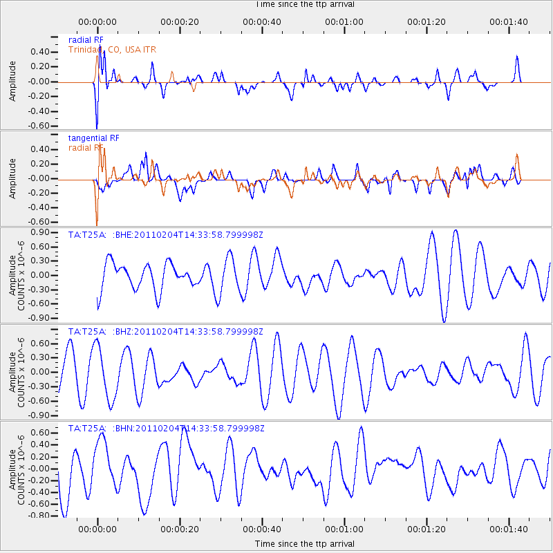
T25A Trinidad, CO, USA - Earthquake Result Viewer
*The percent match for this event was below the threshold and hence no stack was calculated.
| Earthquake location: |
Vanuatu Islands |
| Earthquake latitude/longitude: |
-14.2/166.5 |
| Earthquake time(UTC): |
2011/02/04 (035) 14:20:55 GMT |
| Earthquake Depth: |
10 km |
| Earthquake Magnitude: |
5.8 MB, 5.9 MW |
| Earthquake Catalog/Contributor: |
WHDF/NEIC |
|
| Network: |
TA USArray Transportable Network (new EarthScope stations) |
| Station: |
T25A Trinidad, CO, USA |
| Lat/Lon: |
37.14 N/104.41 W |
| Elevation: |
2017 m |
|
| Distance: |
97.7 deg |
| Az: |
53.743 deg |
| Baz: |
258.15 deg |
| Ray Param: |
$rayparam |
*The percent match for this event was below the threshold and hence was not used in the summary stack. |
|
| Radial Match: |
76.64536 % |
| Radial Bump: |
400 |
| Transverse Match: |
40.042614 % |
| Transverse Bump: |
400 |
| SOD ConfigId: |
350818 |
| Insert Time: |
2011-07-20 13:10:28.989 +0000 |
| GWidth: |
2.5 |
| Max Bumps: |
400 |
| Tol: |
0.001 |
|
Signal To Noise
| Channel | StoN | STA | LTA |
| TA:T25A: :BHZ:20110204T14:33:58.799998Z | 1.7866755 | 5.5742885E-7 | 3.1199224E-7 |
| TA:T25A: :BHN:20110204T14:33:58.799998Z | 1.1003685 | 4.1446398E-7 | 3.7665927E-7 |
| TA:T25A: :BHE:20110204T14:33:58.799998Z | 1.4407045 | 3.9008387E-7 | 2.707591E-7 |
| Arrivals |
| Ps | |
| PpPs | |
| PsPs/PpSs | |


