You are here: Home > Network List > IC - New China Digital Seismograph Network Stations List
> Station LSA Tibet, China > Earthquake Result Viewer
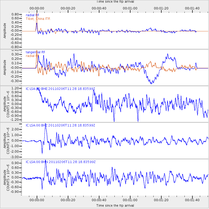
LSA Tibet, China - Earthquake Result Viewer
*The percent match for this event was below the threshold and hence no stack was calculated.
| Earthquake location: |
Southwest Of Sumatra, Indonesia |
| Earthquake latitude/longitude: |
-8.3/104.1 |
| Earthquake time(UTC): |
2011/02/06 (037) 11:21:17 GMT |
| Earthquake Depth: |
13 km |
| Earthquake Magnitude: |
5.6 MB, 5.2 MS, 5.7 MW, 5.6 MW |
| Earthquake Catalog/Contributor: |
WHDF/NEIC |
|
| Network: |
IC New China Digital Seismograph Network |
| Station: |
LSA Tibet, China |
| Lat/Lon: |
29.70 N/91.13 E |
| Elevation: |
3660 m |
|
| Distance: |
39.8 deg |
| Az: |
342.255 deg |
| Baz: |
159.714 deg |
| Ray Param: |
$rayparam |
*The percent match for this event was below the threshold and hence was not used in the summary stack. |
|
| Radial Match: |
80.40446 % |
| Radial Bump: |
400 |
| Transverse Match: |
55.80487 % |
| Transverse Bump: |
400 |
| SOD ConfigId: |
350818 |
| Insert Time: |
2011-07-22 06:51:57.589 +0000 |
| GWidth: |
2.5 |
| Max Bumps: |
400 |
| Tol: |
0.001 |
|
Signal To Noise
| Channel | StoN | STA | LTA |
| IC:LSA:00:BHZ:20110206T11:28:18.83599Z | 10.688054 | 6.3900274E-7 | 5.978663E-8 |
| IC:LSA:00:BHN:20110206T11:28:18.83599Z | 3.0044146 | 2.0501788E-7 | 6.8238876E-8 |
| IC:LSA:00:BHE:20110206T11:28:18.83599Z | 0.43403402 | 1.9709537E-7 | 4.5410124E-7 |
| Arrivals |
| Ps | |
| PpPs | |
| PsPs/PpSs | |


