You are here: Home > Network List > XG92 - Rocky Mountain Front Stations List
> Station MBL Maybell, CO > Earthquake Result Viewer
MBL Maybell, CO - Earthquake Result Viewer
| Earthquake location: |
Svalbard Region |
| Earthquake latitude/longitude: |
76.2/7.2 |
| Earthquake time(UTC): |
1992/09/09 (253) 13:08:54 GMT |
| Earthquake Depth: |
24 km |
| Earthquake Magnitude: |
5.7 MB, 5.6 MS |
| Earthquake Catalog/Contributor: |
WHDF/NEIC |
|
| Network: |
XG Rocky Mountain Front |
| Station: |
MBL Maybell, CO |
| Lat/Lon: |
40.56 N/108.10 W |
| Elevation: |
1866 m |
|
| Distance: |
56.6 deg |
| Az: |
304.427 deg |
| Baz: |
15.057 deg |
| Ray Param: |
0.06400259 |
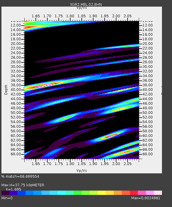
| Estimated Moho Depth: |
37.75 km |
| Estimated Crust Vp/Vs: |
1.70 |
| Assumed Crust Vp: |
6.207 km/s |
| Estimated Crust Vs: |
3.662 km/s |
| Estimated Crust Poisson's Ratio: |
0.23 |
|
| Radial Match: |
86.699554 % |
| Radial Bump: |
400 |
| Transverse Match: |
74.902016 % |
| Transverse Bump: |
400 |
| SOD ConfigId: |
3286 |
| Insert Time: |
2010-02-25 20:10:00.602 +0000 |
| GWidth: |
2.5 |
| Max Bumps: |
400 |
| Tol: |
0.001 |
|

Signal To Noise
| Channel | StoN | STA | LTA |
| XG:MBL:02:BHN:19920909T13:18:04.530017Z | 2.096667 | 4.980691E-4 | 2.3755277E-4 |
| XG:MBL:02:BHE:19920909T13:18:04.530017Z | 1.0060842 | 1.5425311E-4 | 1.5332027E-4 |
| XG:MBL:02:BHZ:19920909T13:18:04.530017Z | 9.782274 | 0.0016214794 | 1.657569E-4 |
| Arrivals |
| Ps | 4.4 SECOND |
| PpPs | 16 SECOND |
| PsPs/PpSs | 20 SECOND |


