You are here: Home > Network List > CI - Caltech Regional Seismic Network Stations List
> Station TUQ Turquiose Mountain, Baker, CA, USA > Earthquake Result Viewer
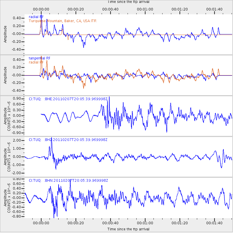
TUQ Turquiose Mountain, Baker, CA, USA - Earthquake Result Viewer
*The percent match for this event was below the threshold and hence no stack was calculated.
| Earthquake location: |
Solomon Islands |
| Earthquake latitude/longitude: |
-7.2/155.2 |
| Earthquake time(UTC): |
2011/02/07 (038) 19:53:44 GMT |
| Earthquake Depth: |
429 km |
| Earthquake Magnitude: |
5.9 MB, 6.4 MW, 6.4 MW |
| Earthquake Catalog/Contributor: |
WHDF/NEIC |
|
| Network: |
CI Caltech Regional Seismic Network |
| Station: |
TUQ Turquiose Mountain, Baker, CA, USA |
| Lat/Lon: |
35.44 N/115.92 W |
| Elevation: |
1350 m |
|
| Distance: |
93.2 deg |
| Az: |
54.858 deg |
| Baz: |
263.553 deg |
| Ray Param: |
$rayparam |
*The percent match for this event was below the threshold and hence was not used in the summary stack. |
|
| Radial Match: |
60.268394 % |
| Radial Bump: |
400 |
| Transverse Match: |
71.43632 % |
| Transverse Bump: |
400 |
| SOD ConfigId: |
350818 |
| Insert Time: |
2011-07-22 07:12:17.284 +0000 |
| GWidth: |
2.5 |
| Max Bumps: |
400 |
| Tol: |
0.001 |
|
Signal To Noise
| Channel | StoN | STA | LTA |
| CI:TUQ: :BHZ:20110207T20:05:39.969998Z | 1.9722866 | 3.3616345E-7 | 1.7044351E-7 |
| CI:TUQ: :BHN:20110207T20:05:39.969998Z | 1.7358849 | 1.7232652E-7 | 9.9273E-8 |
| CI:TUQ: :BHE:20110207T20:05:39.969998Z | 1.3666227 | 2.0748453E-7 | 1.5182283E-7 |
| Arrivals |
| Ps | |
| PpPs | |
| PsPs/PpSs | |


