You are here: Home > Network List > G - GEOSCOPE Stations List
> Station FOMA Nahampoana reservation, Fort Dauphin, Madagascar > Earthquake Result Viewer
FOMA Nahampoana reservation, Fort Dauphin, Madagascar - Earthquake Result Viewer
| Earthquake location: |
Celebes Sea |
| Earthquake latitude/longitude: |
4.2/123.0 |
| Earthquake time(UTC): |
2011/02/10 (041) 14:39:27 GMT |
| Earthquake Depth: |
523 km |
| Earthquake Magnitude: |
6.1 MB, 6.5 MW, 6.5 MW |
| Earthquake Catalog/Contributor: |
WHDF/NEIC |
|
| Network: |
G GEOSCOPE |
| Station: |
FOMA Nahampoana reservation, Fort Dauphin, Madagascar |
| Lat/Lon: |
24.98 S/46.98 E |
| Elevation: |
26 m |
|
| Distance: |
79.1 deg |
| Az: |
243.724 deg |
| Baz: |
80.192 deg |
| Ray Param: |
0.047599517 |
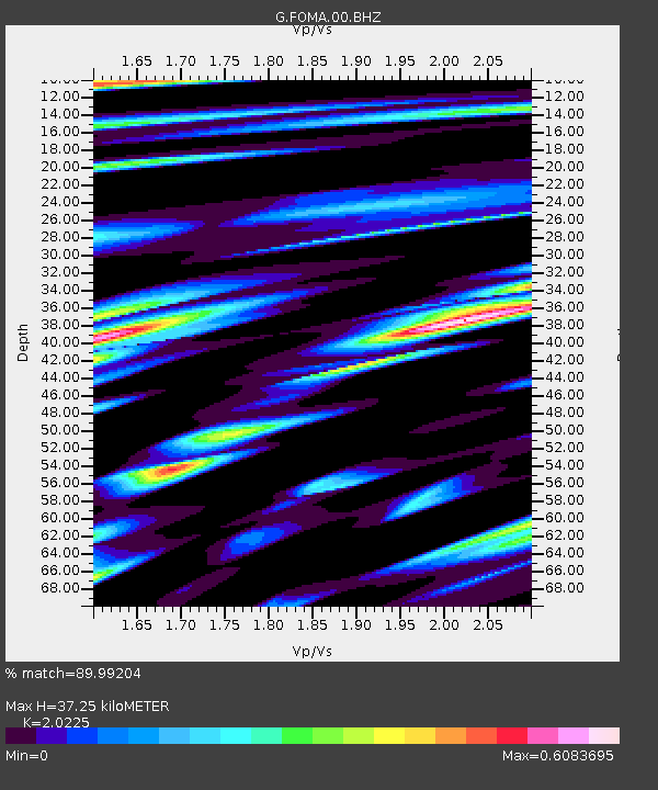
| Estimated Moho Depth: |
37.25 km |
| Estimated Crust Vp/Vs: |
2.02 |
| Assumed Crust Vp: |
6.183 km/s |
| Estimated Crust Vs: |
3.057 km/s |
| Estimated Crust Poisson's Ratio: |
0.34 |
|
| Radial Match: |
89.99204 % |
| Radial Bump: |
400 |
| Transverse Match: |
61.196697 % |
| Transverse Bump: |
400 |
| SOD ConfigId: |
350818 |
| Insert Time: |
2011-07-22 07:50:51.710 +0000 |
| GWidth: |
2.5 |
| Max Bumps: |
400 |
| Tol: |
0.001 |
|

Signal To Noise
| Channel | StoN | STA | LTA |
| G:FOMA:00:BHZ:20110210T14:50:06.749978Z | 9.305777 | 2.6980429E-6 | 2.8993207E-7 |
| G:FOMA:00:BHN:20110210T14:50:06.749978Z | 1.4981661 | 4.4817816E-7 | 2.9915117E-7 |
| G:FOMA:00:BHE:20110210T14:50:06.749978Z | 5.892341 | 1.2714569E-6 | 2.1578127E-7 |
| Arrivals |
| Ps | 6.3 SECOND |
| PpPs | 18 SECOND |
| PsPs/PpSs | 24 SECOND |


