You are here: Home > Network List > XG92 - Rocky Mountain Front Stations List
> Station MBL Maybell, CO > Earthquake Result Viewer
MBL Maybell, CO - Earthquake Result Viewer
| Earthquake location: |
Near Coast Of Nicaragua |
| Earthquake latitude/longitude: |
11.3/-86.8 |
| Earthquake time(UTC): |
1992/09/02 (246) 18:28:56 GMT |
| Earthquake Depth: |
10 km |
| Earthquake Magnitude: |
5.2 MB, 5.8 MS |
| Earthquake Catalog/Contributor: |
WHDF/NEIC |
|
| Network: |
XG Rocky Mountain Front |
| Station: |
MBL Maybell, CO |
| Lat/Lon: |
40.56 N/108.10 W |
| Elevation: |
1866 m |
|
| Distance: |
34.7 deg |
| Az: |
330.854 deg |
| Baz: |
141.168 deg |
| Ray Param: |
0.0775985 |
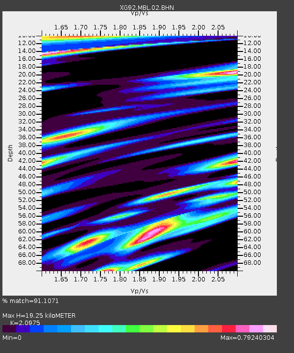
| Estimated Moho Depth: |
19.25 km |
| Estimated Crust Vp/Vs: |
2.10 |
| Assumed Crust Vp: |
6.207 km/s |
| Estimated Crust Vs: |
2.959 km/s |
| Estimated Crust Poisson's Ratio: |
0.35 |
|
| Radial Match: |
91.1071 % |
| Radial Bump: |
311 |
| Transverse Match: |
80.878914 % |
| Transverse Bump: |
400 |
| SOD ConfigId: |
3286 |
| Insert Time: |
2010-02-25 20:10:04.328 +0000 |
| GWidth: |
2.5 |
| Max Bumps: |
400 |
| Tol: |
0.001 |
|

Signal To Noise
| Channel | StoN | STA | LTA |
| XG:MBL:02:BHN:19920902T18:35:15.630011Z | 1.4120959 | 3.1499992E-4 | 2.2307261E-4 |
| XG:MBL:02:BHE:19920902T18:35:15.630011Z | 1.6858966 | 3.34538E-4 | 1.9843328E-4 |
| XG:MBL:02:BHZ:19920902T18:35:15.630011Z | 6.843903 | 7.845718E-4 | 1.14638075E-4 |
| Arrivals |
| Ps | 3.6 SECOND |
| PpPs | 9.0 SECOND |
| PsPs/PpSs | 13 SECOND |


