You are here: Home > Network List > G - GEOSCOPE Stations List
> Station FOMA Nahampoana reservation, Fort Dauphin, Madagascar > Earthquake Result Viewer
FOMA Nahampoana reservation, Fort Dauphin, Madagascar - Earthquake Result Viewer
| Earthquake location: |
Celebes Sea |
| Earthquake latitude/longitude: |
4.1/123.0 |
| Earthquake time(UTC): |
2011/02/10 (041) 14:41:58 GMT |
| Earthquake Depth: |
525 km |
| Earthquake Magnitude: |
6.3 MB, 6.6 MW, 6.5 MW |
| Earthquake Catalog/Contributor: |
WHDF/NEIC |
|
| Network: |
G GEOSCOPE |
| Station: |
FOMA Nahampoana reservation, Fort Dauphin, Madagascar |
| Lat/Lon: |
24.98 S/46.98 E |
| Elevation: |
26 m |
|
| Distance: |
79.1 deg |
| Az: |
243.754 deg |
| Baz: |
80.328 deg |
| Ray Param: |
0.047588315 |
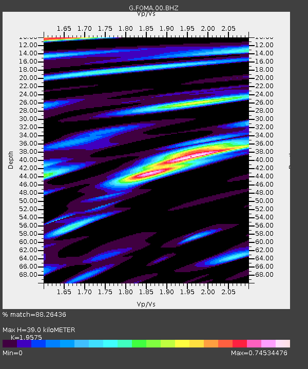
| Estimated Moho Depth: |
39.0 km |
| Estimated Crust Vp/Vs: |
1.96 |
| Assumed Crust Vp: |
6.183 km/s |
| Estimated Crust Vs: |
3.158 km/s |
| Estimated Crust Poisson's Ratio: |
0.32 |
|
| Radial Match: |
88.26436 % |
| Radial Bump: |
388 |
| Transverse Match: |
79.76283 % |
| Transverse Bump: |
400 |
| SOD ConfigId: |
350818 |
| Insert Time: |
2011-07-22 08:13:08.931 +0000 |
| GWidth: |
2.5 |
| Max Bumps: |
400 |
| Tol: |
0.001 |
|

Signal To Noise
| Channel | StoN | STA | LTA |
| G:FOMA:00:BHZ:20110210T14:52:37.749993Z | 5.1143923 | 4.082488E-6 | 7.982352E-7 |
| G:FOMA:00:BHN:20110210T14:52:37.749993Z | 1.7272134 | 4.207023E-7 | 2.4357286E-7 |
| G:FOMA:00:BHE:20110210T14:52:37.749993Z | 3.145285 | 1.5481814E-6 | 4.922229E-7 |
| Arrivals |
| Ps | 6.2 SECOND |
| PpPs | 18 SECOND |
| PsPs/PpSs | 24 SECOND |


