You are here: Home > Network List > IU - Global Seismograph Network (GSN - IRIS/USGS) Stations List
> Station PMG Port Moresby, New Guinea > Earthquake Result Viewer
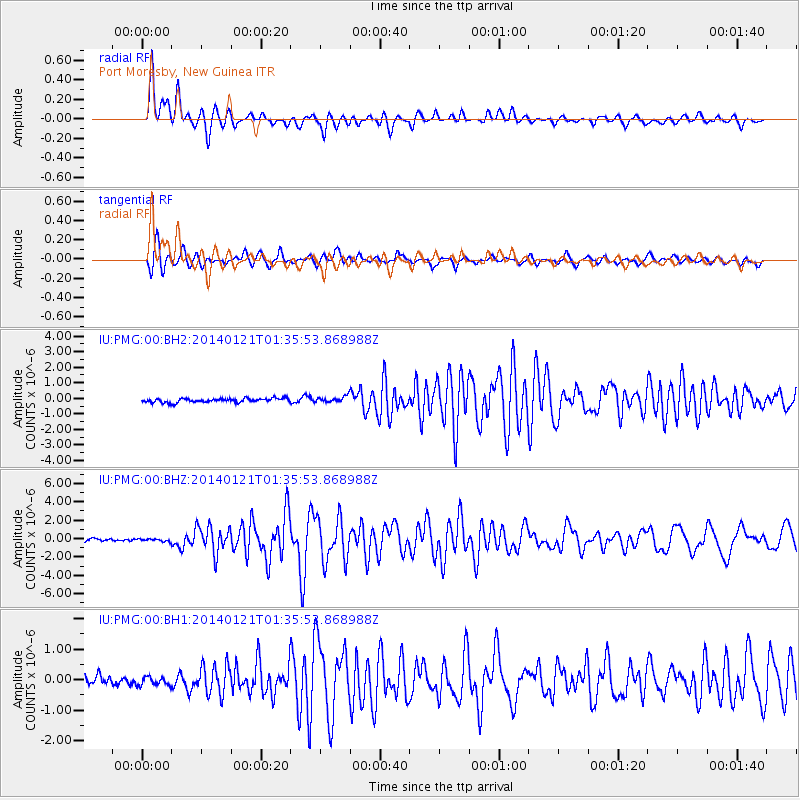
PMG Port Moresby, New Guinea - Earthquake Result Viewer
*The percent match for this event was below the threshold and hence no stack was calculated.
| Earthquake location: |
Tonga Islands |
| Earthquake latitude/longitude: |
-15.1/-174.7 |
| Earthquake time(UTC): |
2014/01/21 (021) 01:29:07 GMT |
| Earthquake Depth: |
6.1 km |
| Earthquake Magnitude: |
6.1 MWW, 6.1 MWB, 6.2 MWC, 6.5 MI |
| Earthquake Catalog/Contributor: |
NEIC PDE/NEIC COMCAT |
|
| Network: |
IU Global Seismograph Network (GSN - IRIS/USGS) |
| Station: |
PMG Port Moresby, New Guinea |
| Lat/Lon: |
9.40 S/147.16 E |
| Elevation: |
90 m |
|
| Distance: |
37.7 deg |
| Az: |
274.189 deg |
| Baz: |
102.557 deg |
| Ray Param: |
$rayparam |
*The percent match for this event was below the threshold and hence was not used in the summary stack. |
|
| Radial Match: |
83.766754 % |
| Radial Bump: |
400 |
| Transverse Match: |
82.17172 % |
| Transverse Bump: |
400 |
| SOD ConfigId: |
3390531 |
| Insert Time: |
2019-04-10 01:37:48.853 +0000 |
| GWidth: |
2.5 |
| Max Bumps: |
400 |
| Tol: |
0.001 |
|
Signal To Noise
| Channel | StoN | STA | LTA |
| IU:PMG:00:BHZ:20140121T01:35:53.868988Z | 0.80934393 | 1.4045486E-7 | 1.7354164E-7 |
| IU:PMG:00:BH1:20140121T01:35:53.868988Z | 1.0333732 | 1.3727228E-7 | 1.32839E-7 |
| IU:PMG:00:BH2:20140121T01:35:53.868988Z | 1.3736459 | 1.7564675E-7 | 1.2786901E-7 |
| Arrivals |
| Ps | |
| PpPs | |
| PsPs/PpSs | |


