You are here: Home > Network List > XG92 - Rocky Mountain Front Stations List
> Station MBL Maybell, CO > Earthquake Result Viewer
MBL Maybell, CO - Earthquake Result Viewer
| Earthquake location: |
Near Coast Of Nicaragua |
| Earthquake latitude/longitude: |
11.8/-87.4 |
| Earthquake time(UTC): |
1992/09/02 (246) 00:15:57 GMT |
| Earthquake Depth: |
10 km |
| Earthquake Magnitude: |
5.3 MB, 7.2 MS |
| Earthquake Catalog/Contributor: |
WHDF/NEIC |
|
| Network: |
XG Rocky Mountain Front |
| Station: |
MBL Maybell, CO |
| Lat/Lon: |
40.56 N/108.10 W |
| Elevation: |
1866 m |
|
| Distance: |
34.0 deg |
| Az: |
331.223 deg |
| Baz: |
141.776 deg |
| Ray Param: |
0.07795756 |
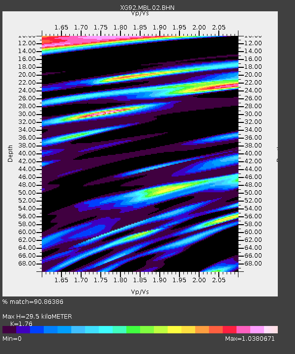
| Estimated Moho Depth: |
29.5 km |
| Estimated Crust Vp/Vs: |
1.76 |
| Assumed Crust Vp: |
6.207 km/s |
| Estimated Crust Vs: |
3.527 km/s |
| Estimated Crust Poisson's Ratio: |
0.26 |
|
| Radial Match: |
90.86386 % |
| Radial Bump: |
400 |
| Transverse Match: |
81.793785 % |
| Transverse Bump: |
400 |
| SOD ConfigId: |
3286 |
| Insert Time: |
2010-02-25 20:10:06.314 +0000 |
| GWidth: |
2.5 |
| Max Bumps: |
400 |
| Tol: |
0.001 |
|

Signal To Noise
| Channel | StoN | STA | LTA |
| XG:MBL:02:BHN:19920902T00:22:10.432007Z | 0.99928695 | 1.8264612E-4 | 1.8277645E-4 |
| XG:MBL:02:BHE:19920902T00:22:10.432007Z | 1.1378986 | 1.6411605E-4 | 1.442273E-4 |
| XG:MBL:02:BHZ:19920902T00:22:10.432007Z | 2.002601 | 2.5985827E-4 | 1.2976037E-4 |
| Arrivals |
| Ps | 3.9 SECOND |
| PpPs | 12 SECOND |
| PsPs/PpSs | 16 SECOND |


