You are here: Home > Network List > US - United States National Seismic Network Stations List
> Station ELK Elko, Nevada, USA > Earthquake Result Viewer
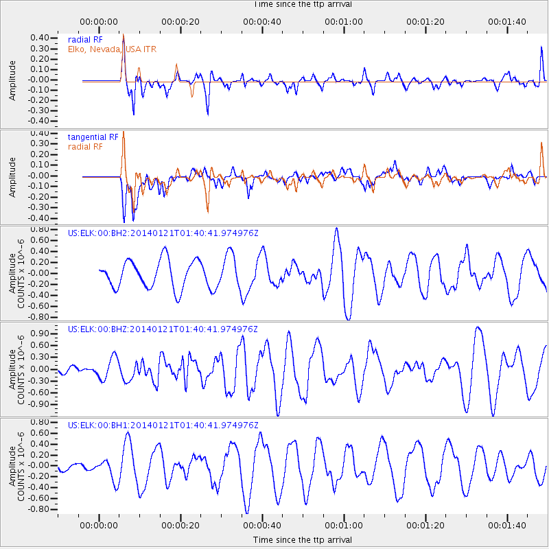
ELK Elko, Nevada, USA - Earthquake Result Viewer
*The percent match for this event was below the threshold and hence no stack was calculated.
| Earthquake location: |
Tonga Islands |
| Earthquake latitude/longitude: |
-15.1/-174.7 |
| Earthquake time(UTC): |
2014/01/21 (021) 01:29:07 GMT |
| Earthquake Depth: |
6.1 km |
| Earthquake Magnitude: |
6.1 MWW, 6.1 MWB, 6.2 MWC, 6.5 MI |
| Earthquake Catalog/Contributor: |
NEIC PDE/NEIC COMCAT |
|
| Network: |
US United States National Seismic Network |
| Station: |
ELK Elko, Nevada, USA |
| Lat/Lon: |
40.74 N/115.24 W |
| Elevation: |
2210 m |
|
| Distance: |
78.2 deg |
| Az: |
41.94 deg |
| Baz: |
238.157 deg |
| Ray Param: |
$rayparam |
*The percent match for this event was below the threshold and hence was not used in the summary stack. |
|
| Radial Match: |
55.27772 % |
| Radial Bump: |
381 |
| Transverse Match: |
44.68232 % |
| Transverse Bump: |
400 |
| SOD ConfigId: |
3390531 |
| Insert Time: |
2019-04-10 01:39:33.942 +0000 |
| GWidth: |
2.5 |
| Max Bumps: |
400 |
| Tol: |
0.001 |
|
Signal To Noise
| Channel | StoN | STA | LTA |
| US:ELK:00:BHZ:20140121T01:40:41.974976Z | 2.2017817 | 2.809641E-7 | 1.2760759E-7 |
| US:ELK:00:BH1:20140121T01:40:41.974976Z | 1.3773837 | 2.1454927E-7 | 1.557658E-7 |
| US:ELK:00:BH2:20140121T01:40:41.974976Z | 1.1132517 | 2.6240772E-7 | 2.3571285E-7 |
| Arrivals |
| Ps | |
| PpPs | |
| PsPs/PpSs | |


