You are here: Home > Network List > TA - USArray Transportable Network (new EarthScope stations) Stations List
> Station SFIN Lafayette, IN, USA > Earthquake Result Viewer
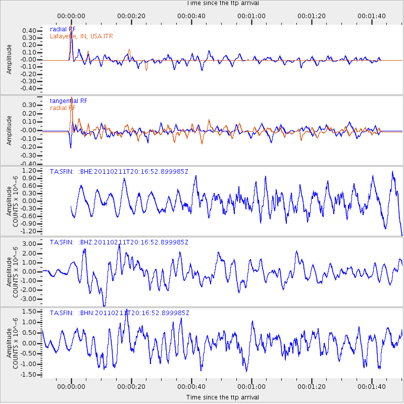
SFIN Lafayette, IN, USA - Earthquake Result Viewer
*The percent match for this event was below the threshold and hence no stack was calculated.
| Earthquake location: |
Near Coast Of Central Chile |
| Earthquake latitude/longitude: |
-36.5/-73.1 |
| Earthquake time(UTC): |
2011/02/11 (042) 20:05:30 GMT |
| Earthquake Depth: |
28 km |
| Earthquake Magnitude: |
6.0 MB, 6.8 MW, 6.8 MW |
| Earthquake Catalog/Contributor: |
WHDF/NEIC |
|
| Network: |
TA USArray Transportable Network (new EarthScope stations) |
| Station: |
SFIN Lafayette, IN, USA |
| Lat/Lon: |
40.38 N/87.10 W |
| Elevation: |
165 m |
|
| Distance: |
77.6 deg |
| Az: |
349.112 deg |
| Baz: |
168.504 deg |
| Ray Param: |
$rayparam |
*The percent match for this event was below the threshold and hence was not used in the summary stack. |
|
| Radial Match: |
67.77085 % |
| Radial Bump: |
358 |
| Transverse Match: |
58.19252 % |
| Transverse Bump: |
400 |
| SOD ConfigId: |
350818 |
| Insert Time: |
2011-07-22 08:51:18.448 +0000 |
| GWidth: |
2.5 |
| Max Bumps: |
400 |
| Tol: |
0.001 |
|
Signal To Noise
| Channel | StoN | STA | LTA |
| TA:SFIN: :BHZ:20110211T20:16:52.899985Z | 4.574615 | 1.2722676E-6 | 2.7811467E-7 |
| TA:SFIN: :BHN:20110211T20:16:52.899985Z | 0.9077119 | 4.458358E-7 | 4.911644E-7 |
| TA:SFIN: :BHE:20110211T20:16:52.899985Z | 0.71047235 | 2.63275E-7 | 3.7056336E-7 |
| Arrivals |
| Ps | |
| PpPs | |
| PsPs/PpSs | |


