You are here: Home > Network List > TA - USArray Transportable Network (new EarthScope stations) Stations List
> Station L30A Spencer Herefords Ranch, Brewster, NE, USA > Earthquake Result Viewer
L30A Spencer Herefords Ranch, Brewster, NE, USA - Earthquake Result Viewer
| Earthquake location: |
Near Coast Of Central Chile |
| Earthquake latitude/longitude: |
-36.5/-73.1 |
| Earthquake time(UTC): |
2011/02/11 (042) 20:05:30 GMT |
| Earthquake Depth: |
28 km |
| Earthquake Magnitude: |
6.0 MB, 6.8 MW, 6.8 MW |
| Earthquake Catalog/Contributor: |
WHDF/NEIC |
|
| Network: |
TA USArray Transportable Network (new EarthScope stations) |
| Station: |
L30A Spencer Herefords Ranch, Brewster, NE, USA |
| Lat/Lon: |
41.95 N/99.72 W |
| Elevation: |
782 m |
|
| Distance: |
81.8 deg |
| Az: |
340.279 deg |
| Baz: |
158.616 deg |
| Ray Param: |
0.04733279 |
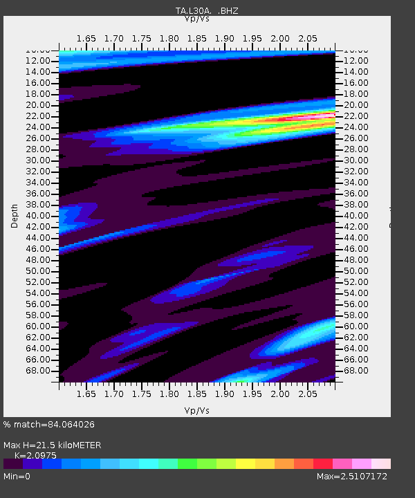
| Estimated Moho Depth: |
21.5 km |
| Estimated Crust Vp/Vs: |
2.10 |
| Assumed Crust Vp: |
6.53 km/s |
| Estimated Crust Vs: |
3.113 km/s |
| Estimated Crust Poisson's Ratio: |
0.35 |
|
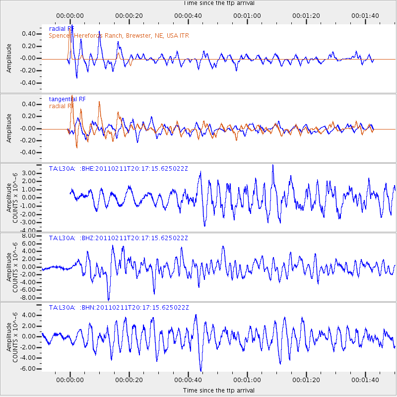
| Radial Match: |
84.064026 % |
| Radial Bump: |
377 |
| Transverse Match: |
62.105324 % |
| Transverse Bump: |
400 |
| SOD ConfigId: |
350818 |
| Insert Time: |
2011-07-22 09:15:30.513 +0000 |
| GWidth: |
2.5 |
| Max Bumps: |
400 |
| Tol: |
0.001 |
|
Signal To Noise
| Channel | StoN | STA | LTA |
| TA:L30A: :BHZ:20110211T20:17:15.625022Z | 4.460926 | 1.0678025E-6 | 2.3936792E-7 |
| TA:L30A: :BHN:20110211T20:17:15.625022Z | 1.1193581 | 8.782254E-7 | 7.845796E-7 |
| TA:L30A: :BHE:20110211T20:17:15.625022Z | 1.0681894 | 7.487297E-7 | 7.0093347E-7 |
| Arrivals |
| Ps | 3.7 SECOND |
| PpPs | 10.0 SECOND |
| PsPs/PpSs | 14 SECOND |


