You are here: Home > Network List > TA - USArray Transportable Network (new EarthScope stations) Stations List
> Station S33A Kaszmaul Farm, Murdock, KS, USA > Earthquake Result Viewer
S33A Kaszmaul Farm, Murdock, KS, USA - Earthquake Result Viewer
| Earthquake location: |
Near Coast Of Central Chile |
| Earthquake latitude/longitude: |
-36.5/-73.1 |
| Earthquake time(UTC): |
2011/02/11 (042) 20:05:30 GMT |
| Earthquake Depth: |
28 km |
| Earthquake Magnitude: |
6.0 MB, 6.8 MW, 6.8 MW |
| Earthquake Catalog/Contributor: |
WHDF/NEIC |
|
| Network: |
TA USArray Transportable Network (new EarthScope stations) |
| Station: |
S33A Kaszmaul Farm, Murdock, KS, USA |
| Lat/Lon: |
37.59 N/98.00 W |
| Elevation: |
471 m |
|
| Distance: |
77.2 deg |
| Az: |
339.962 deg |
| Baz: |
159.654 deg |
| Ray Param: |
0.050438844 |
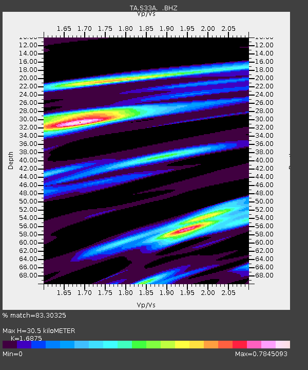
| Estimated Moho Depth: |
30.5 km |
| Estimated Crust Vp/Vs: |
1.69 |
| Assumed Crust Vp: |
6.426 km/s |
| Estimated Crust Vs: |
3.808 km/s |
| Estimated Crust Poisson's Ratio: |
0.23 |
|
| Radial Match: |
83.30325 % |
| Radial Bump: |
339 |
| Transverse Match: |
75.09226 % |
| Transverse Bump: |
399 |
| SOD ConfigId: |
350818 |
| Insert Time: |
2011-07-22 09:21:06.643 +0000 |
| GWidth: |
2.5 |
| Max Bumps: |
400 |
| Tol: |
0.001 |
|
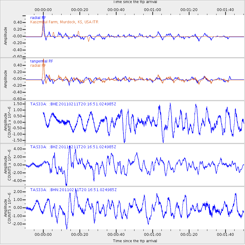
Signal To Noise
| Channel | StoN | STA | LTA |
| TA:S33A: :BHZ:20110211T20:16:51.024985Z | 2.3779037 | 8.9598336E-7 | 3.767955E-7 |
| TA:S33A: :BHN:20110211T20:16:51.024985Z | 1.646541 | 7.0093074E-7 | 4.2569891E-7 |
| TA:S33A: :BHE:20110211T20:16:51.024985Z | 1.031522 | 4.1473768E-7 | 4.0206385E-7 |
| Arrivals |
| Ps | 3.4 SECOND |
| PpPs | 12 SECOND |
| PsPs/PpSs | 16 SECOND |


