You are here: Home > Network List > TA - USArray Transportable Network (new EarthScope stations) Stations List
> Station X32A Elmer, OK, USA > Earthquake Result Viewer
X32A Elmer, OK, USA - Earthquake Result Viewer
| Earthquake location: |
Near Coast Of Central Chile |
| Earthquake latitude/longitude: |
-36.5/-73.1 |
| Earthquake time(UTC): |
2011/02/11 (042) 20:05:30 GMT |
| Earthquake Depth: |
28 km |
| Earthquake Magnitude: |
6.0 MB, 6.8 MW, 6.8 MW |
| Earthquake Catalog/Contributor: |
WHDF/NEIC |
|
| Network: |
TA USArray Transportable Network (new EarthScope stations) |
| Station: |
X32A Elmer, OK, USA |
| Lat/Lon: |
34.42 N/99.29 W |
| Elevation: |
401 m |
|
| Distance: |
74.6 deg |
| Az: |
337.791 deg |
| Baz: |
158.374 deg |
| Ray Param: |
0.052167132 |
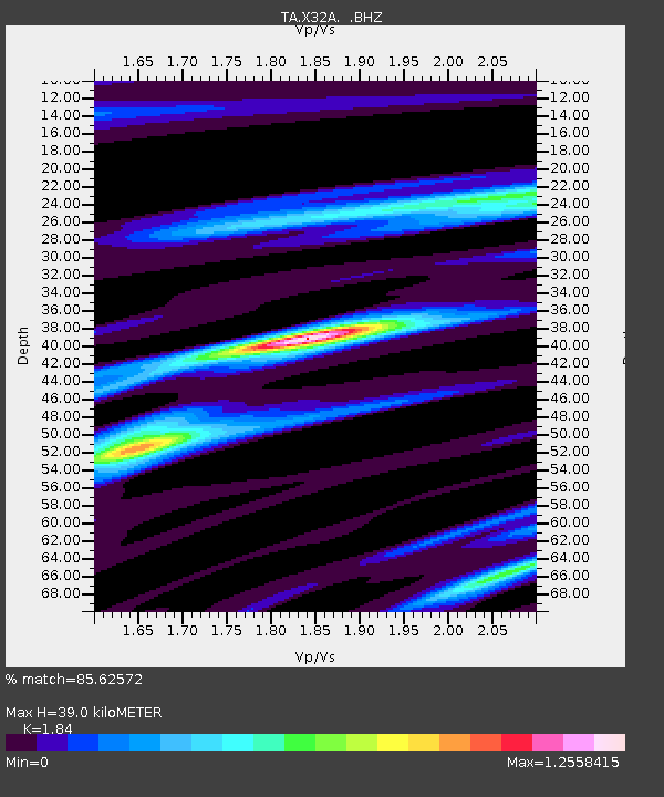
| Estimated Moho Depth: |
39.0 km |
| Estimated Crust Vp/Vs: |
1.84 |
| Assumed Crust Vp: |
6.315 km/s |
| Estimated Crust Vs: |
3.432 km/s |
| Estimated Crust Poisson's Ratio: |
0.29 |
|
| Radial Match: |
85.62572 % |
| Radial Bump: |
291 |
| Transverse Match: |
69.690315 % |
| Transverse Bump: |
400 |
| SOD ConfigId: |
350818 |
| Insert Time: |
2011-07-22 09:22:23.067 +0000 |
| GWidth: |
2.5 |
| Max Bumps: |
400 |
| Tol: |
0.001 |
|

Signal To Noise
| Channel | StoN | STA | LTA |
| TA:X32A: :BHZ:20110211T20:16:36.349998Z | 3.7111113 | 8.382167E-7 | 2.2586677E-7 |
| TA:X32A: :BHN:20110211T20:16:36.349998Z | 0.7341576 | 2.3292117E-7 | 3.1726316E-7 |
| TA:X32A: :BHE:20110211T20:16:36.349998Z | 4.2805676 | 6.6562836E-7 | 1.5550003E-7 |
| Arrivals |
| Ps | 5.3 SECOND |
| PpPs | 17 SECOND |
| PsPs/PpSs | 22 SECOND |


