You are here: Home > Network List > TA - USArray Transportable Network (new EarthScope stations) Stations List
> Station 534A Blanco, TX, USA > Earthquake Result Viewer
534A Blanco, TX, USA - Earthquake Result Viewer
| Earthquake location: |
Near Coast Of Central Chile |
| Earthquake latitude/longitude: |
-36.5/-73.1 |
| Earthquake time(UTC): |
2011/02/11 (042) 20:05:30 GMT |
| Earthquake Depth: |
28 km |
| Earthquake Magnitude: |
6.0 MB, 6.8 MW, 6.8 MW |
| Earthquake Catalog/Contributor: |
WHDF/NEIC |
|
| Network: |
TA USArray Transportable Network (new EarthScope stations) |
| Station: |
534A Blanco, TX, USA |
| Lat/Lon: |
30.03 N/98.48 W |
| Elevation: |
461 m |
|
| Distance: |
70.3 deg |
| Az: |
336.773 deg |
| Baz: |
158.497 deg |
| Ray Param: |
0.055032946 |
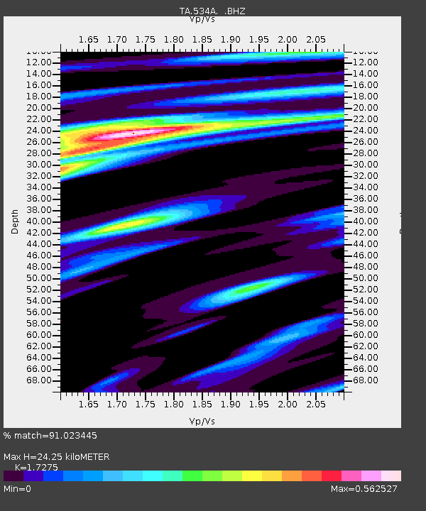
| Estimated Moho Depth: |
24.25 km |
| Estimated Crust Vp/Vs: |
1.73 |
| Assumed Crust Vp: |
6.498 km/s |
| Estimated Crust Vs: |
3.761 km/s |
| Estimated Crust Poisson's Ratio: |
0.25 |
|
| Radial Match: |
91.023445 % |
| Radial Bump: |
333 |
| Transverse Match: |
66.88834 % |
| Transverse Bump: |
400 |
| SOD ConfigId: |
350818 |
| Insert Time: |
2011-07-22 09:26:23.696 +0000 |
| GWidth: |
2.5 |
| Max Bumps: |
400 |
| Tol: |
0.001 |
|
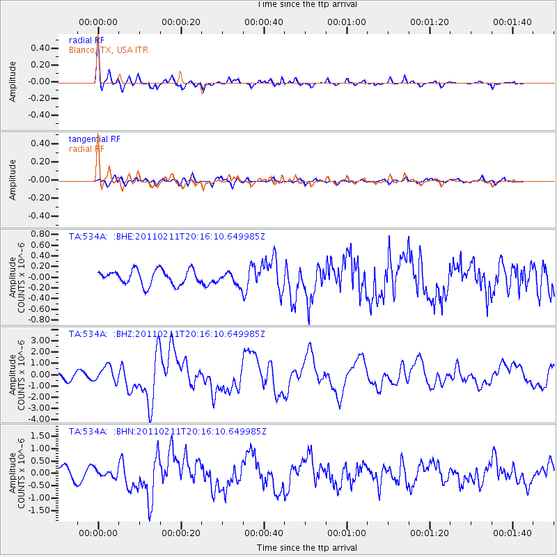
Signal To Noise
| Channel | StoN | STA | LTA |
| TA:534A: :BHZ:20110211T20:16:10.649985Z | 2.8278599 | 6.954688E-7 | 2.4593467E-7 |
| TA:534A: :BHN:20110211T20:16:10.649985Z | 0.7305803 | 1.3228059E-7 | 1.8106236E-7 |
| TA:534A: :BHE:20110211T20:16:10.649985Z | 0.8909633 | 1.2112554E-7 | 1.3594897E-7 |
| Arrivals |
| Ps | 2.8 SECOND |
| PpPs | 9.8 SECOND |
| PsPs/PpSs | 13 SECOND |


